File:CVG airport diagram.svg

Size of this PNG preview of this SVG file: 378 × 548 pixels. Other resolutions: 165 × 240 pixels | 331 × 480 pixels | 530 × 768 pixels | 706 × 1,024 pixels | 1,413 × 2,048 pixels.
Original file (SVG file, nominally 378 × 548 pixels, file size: 1.08 MB)
Captions
Captions
Add a one-line explanation of what this file represents
Summary edit
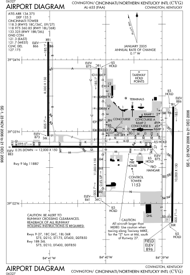
| Description | FAA diagram of Cincinnati/Northern Kentucky International Airport. |
| Date | Diagram is dated November 23, 2006–December 31, 2006 |
| Source | Found via NACO site. Converted from this PDF to SVG using this method. |
| Author | en:FAA |
| Permission (Reusing this file) |
Public domain |
Licensing edit
This image or file is a work of a Federal Aviation Administration employee, taken or made as part of that person's official duties. As a work of the U.S. federal government, the image is in the public domain in the United States.
|
 |
File history
Click on a date/time to view the file as it appeared at that time.
| Date/Time | Thumbnail | Dimensions | User | Comment | |
|---|---|---|---|---|---|
| current | 15:27, 5 January 2007 | | 378 × 548 (1.08 MB) | Grendelkhan (talk | contribs) | {{Information |Description=FAA diagram of Cincinnati/Northern Kentucky International Airport. |Source=Found via [http://gc.kls2.com/airport/CVG Great Circle Mapper]. Converted from [http://www.naco.faa.gov/d-tpp/0612/00655AD.PDF this PDF] to SVG using [[: |
You cannot overwrite this file.
File usage on Commons
There are no pages that use this file.
File usage on other wikis
The following other wikis use this file:
- Usage on de.wikipedia.org
- Usage on fr.wikipedia.org
- Usage on it.wikipedia.org
- Usage on ja.wikipedia.org
- Usage on pl.wikipedia.org
- Usage on pt.wikipedia.org
- Usage on ru.wikipedia.org
- Usage on vi.wikipedia.org
- Usage on zh.wikipedia.org