File:Cadre géographique de la ville de Lille.png
(Redirected from File:Cadre géographique de la ville de Lille.gif)

Size of this preview: 588 × 599 pixels. Other resolutions: 235 × 240 pixels | 471 × 480 pixels | 754 × 768 pixels | 1,005 × 1,024 pixels | 2,009 × 2,048 pixels | 3,277 × 3,340 pixels.
Original file (3,277 × 3,340 pixels, file size: 225 KB, MIME type: image/png)
File information
Structured data
Captions
Captions
Add a one-line explanation of what this file represents
| DescriptionCadre géographique de la ville de Lille.png |
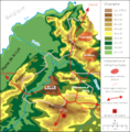
Français : la ville de Lille dans son cadre géographique, carte réalisée en décembre 2005 par Laurent Deschodt d'après les cartes IGN 1/50000
LicensingCatégorie:Cartes et plans de Lille |
| Date | 10 January 2006 (original upload date) |
| Source | Transferred from fr.wikipedia to Commons by Bloody-libu using CommonsHelper. |
| Author | The original uploader was Calbp at French Wikipedia. |
Licensing edit
This file is licensed under the Creative Commons Attribution 1.0 Generic license.
- You are free:
- to share – to copy, distribute and transmit the work
- to remix – to adapt the work
- Under the following conditions:
- attribution – You must give appropriate credit, provide a link to the license, and indicate if changes were made. You may do so in any reasonable manner, but not in any way that suggests the licensor endorses you or your use.
Original upload log edit
The original description page was here. All following user names refer to fr.wikipedia.
- 2006-01-10 07:56 Calbp 3277×3340× (328111 bytes) la ville de Lille dans son cadre géographique, carte réalisée en décembre 2005 par Laurent Deschodt d'après les cartes IGN 1/50000
Original upload log edit
| Date/Time | Dimensions | User | Comment |
|---|---|---|---|
| 9 August 2011, 20:45:34 | 3277 × 3340 (328111 bytes) | File Upload Bot (Magnus Manske) (talk · contribs) | {{BotMoveToCommons|fr.wikipedia|year={{subst:CURRENTYEAR}}|month={{subst:CURRENTMONTHNAME}}|day={{subst:CURRENTDAY}}}} {{Information |Description={{fr|la ville de Lille dans son cadre géographique, carte réalisée en décembre 2005 par Laurent Deschodt |
File history
Click on a date/time to view the file as it appeared at that time.
| Date/Time | Thumbnail | Dimensions | User | Comment | |
|---|---|---|---|---|---|
| current | 01:26, 29 August 2014 |  | 3,277 × 3,340 (225 KB) | GifTagger (talk | contribs) | Bot: Converting file to superior PNG file. (Source: Cadre_géographique_de_la_ville_de_Lille.gif). This GIF was problematic due to transparency and non-greyscale color table. |
You cannot overwrite this file.
File usage on Commons
The following 2 pages use this file:
- Lille
- File:Cadre géographique de la ville de Lille.gif (file redirect)
File usage on other wikis
The following other wikis use this file:
- Usage on de.wikipedia.org
- Usage on fr.wikipedia.org