File:California county map (Inland Empire highlighted) Gold color.svg

Size of this PNG preview of this SVG file: 487 × 599 pixels. Other resolutions: 195 × 240 pixels | 390 × 480 pixels | 624 × 768 pixels | 832 × 1,024 pixels | 1,664 × 2,048 pixels | 650 × 800 pixels.
Original file (SVG file, nominally 650 × 800 pixels, file size: 258 KB)
Captions
Captions
Add a one-line explanation of what this file represents
Summary edit
| Description |
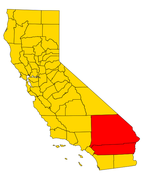
English: A map of the w:Inland Empire (California) metropolitan area of California, which consists of the counties of Riverside and San Bernadino. |
| Date | |
| Source | Own work based on File:California county map (Riverside County highlighted).svg |
| Author | Optigan13 |
| Other versions |
|
.svg)
_Gold_color_no_trans.png)
_Gold_color.svg&action=edit§ion=1)
.svg)
Licensing edit
_Gold_color.svg&action=edit§ion=2)
| I, the copyright holder of this work, release this work into the public domain. This applies worldwide. In some countries this may not be legally possible; if so: I grant anyone the right to use this work for any purpose, without any conditions, unless such conditions are required by law. |
File history
Click on a date/time to view the file as it appeared at that time.
| Date/Time | Thumbnail | Dimensions | User | Comment | |
|---|---|---|---|---|---|
| current | 00:00, 8 August 2009 | | 650 × 800 (258 KB) | Optigan13 (talk | contribs) | == Summary == {{Information |Description={{en|A map of the w:Inland Empire (California) metropolitan area of California, which consists of the counties of Riverside and San Bernadino.}} |Source=Own work based on [[:File:California county map (Riversid |
You cannot overwrite this file.
File usage on Commons
The following page uses this file:
File usage on other wikis
The following other wikis use this file:
- Usage on en.wikipedia.org
- Talk:Chick Publications
- Talk:Terminator 2: Judgment Day
- Talk:Mira Loma, California
- Talk:San Bernardino County, California
- Talk:Bombay Beach, California
- Talk:Church of Scientology
- Talk:Muscoy, California
- Talk:University of California, Riverside
- Talk:Metrolink (California)
- Talk:Rollie Fingers
- Talk:Murrieta, California
- Talk:Salton Sea
- Talk:Vanessa Marcil
- Talk:Baker, California
- Talk:Coachella Valley
- Talk:Ontario International Airport
- Talk:Gary Webb
- Talk:Rancho Cucamonga, California
- Talk:Diana Taurasi
- Talk:Apple Valley, California
- Talk:San Jacinto Peak
- Talk:San Gorgonio Mountain
- Talk:Wildomar, California
- Talk:Mentone, California
- Talk:Redlands, California
- Talk:Zzyzx, California
- Talk:Palm Springs, California
- Talk:Salton Sea State Recreation Area
- Talk:The Mission Inn Hotel & Spa
- Talk:Chemehuevi
- Talk:Auto Club Speedway
- Talk:Moreno Valley, California
- Talk:Chino Hills, California
- Talk:Eagle Mountain, California
- Talk:Joseph Edward Duncan
- Talk:Sea Org
- Talk:Hesperia Unified School District
- Talk:Hesperia, California
- Talk:Colton, California
- Talk:Ontario, California
- Talk:Pomona College
- Talk:March Air Reserve Base
- Talk:Orange Empire Railway Museum
- Talk:Low Desert
- Talk:Hinkley, California
- Talk:Coachella
- Talk:California State Route 86S
- Talk:Blue Jay, California
- Talk:Cahuilla County, California
- Talk:Chino, California
View more global usage of this file.
_Gold_color.svg)
_Gold_color.svg&oldid=845972351)