File:Canada provinces 1881-1886.png
Size of this preview: 694 × 600 pixels. Other resolutions: 278 × 240 pixels | 556 × 480 pixels | 1,000 × 864 pixels.
Original file (1,000 × 864 pixels, file size: 61 KB, MIME type: image/png)
Captions
Captions
Add a one-line explanation of what this file represents
Summary edit
| Description |
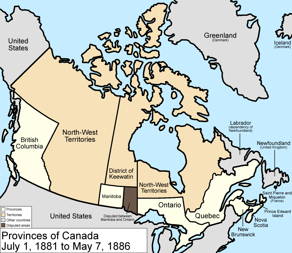
Map of the provinces and territories of Canada as they were between 1881 and 1886. On July 1 1881, Manitoba greatly expanded, using land from the North-West Territories and the District of Keewatin, but a large portion becomes disputed with Ontario. In 1886, the southwestern borders of the District of Keewatin were altered a little, giving a little land to the North-West Territories. Made by User:Golbez. |
| Date | 13 February 2006 (original upload date) |
| Source | No machine-readable source provided. Own work assumed (based on copyright claims). |
| Author | No machine-readable author provided. Golbez assumed (based on copyright claims). |
Licensing edit
I, the copyright holder of this work, hereby publish it under the following licenses:

|
Permission is granted to copy, distribute and/or modify this document under the terms of the GNU Free Documentation License, Version 1.2 or any later version published by the Free Software Foundation; with no Invariant Sections, no Front-Cover Texts, and no Back-Cover Texts. A copy of the license is included in the section entitled GNU Free Documentation License. |
| This file is licensed under the Creative Commons Attribution-Share Alike 3.0 Unported license. | ||
| ||
| This licensing tag was added to this file as part of the GFDL licensing update. |
This file is licensed under the Creative Commons Attribution 2.5 Generic license.
- You are free:
- to share – to copy, distribute and transmit the work
- to remix – to adapt the work
- Under the following conditions:
- attribution – You must give appropriate credit, provide a link to the license, and indicate if changes were made. You may do so in any reasonable manner, but not in any way that suggests the licensor endorses you or your use.
You may select the license of your choice.
File history
Click on a date/time to view the file as it appeared at that time.
| Date/Time | Thumbnail | Dimensions | User | Comment | |
|---|---|---|---|---|---|
| current | 17:20, 14 July 2009 | | 1,000 × 864 (61 KB) | Golbez (talk | contribs) | New color scheme, other borders |
| 09:59, 7 August 2006 |  | 1,000 × 864 (47 KB) | Golbez (talk | contribs) | with legend | |
| 02:24, 18 February 2006 |  | 1,000 × 864 (45 KB) | Golbez (talk | contribs) | Better version | |
| 23:46, 13 February 2006 |  | 1,000 × 864 (42 KB) | Golbez (talk | contribs) | better colors | |
| 10:52, 13 February 2006 |  | 1,000 × 864 (42 KB) | Golbez (talk | contribs) | date | |
| 10:02, 13 February 2006 |  | 1,000 × 864 (41 KB) | Golbez (talk | contribs) | Map of the provinces and territories of Canada as they were between 1881 and 1886. In 1881, Manitoba greatly expanded, using land from the North-West Territories and the District of Keewatin. In 1886, the southwestern borders of the District of Keewatin w |
You cannot overwrite this file.
File usage on Commons
The following page uses this file:
File usage on other wikis
The following other wikis use this file:
- Usage on de.wikipedia.org
- Usage on en.wikipedia.org
- Usage on es.wikipedia.org
- Usage on fr.wikipedia.org
- Usage on it.wikipedia.org
- Usage on pt.wikipedia.org
- Usage on ru.wikipedia.org
- Usage on uk.wikipedia.org
- Usage on vi.wikipedia.org
- Usage on zh.wikipedia.org