File:Canal du Midi map-de.svg

Size of this PNG preview of this SVG file: 800 × 526 pixels. Other resolutions: 320 × 211 pixels | 640 × 421 pixels | 1,024 × 674 pixels | 1,280 × 842 pixels | 2,560 × 1,685 pixels | 1,047 × 689 pixels.
Original file (SVG file, nominally 1,047 × 689 pixels, file size: 551 KB)
Captions
Captions
Add a one-line explanation of what this file represents
Summary edit
| Description |
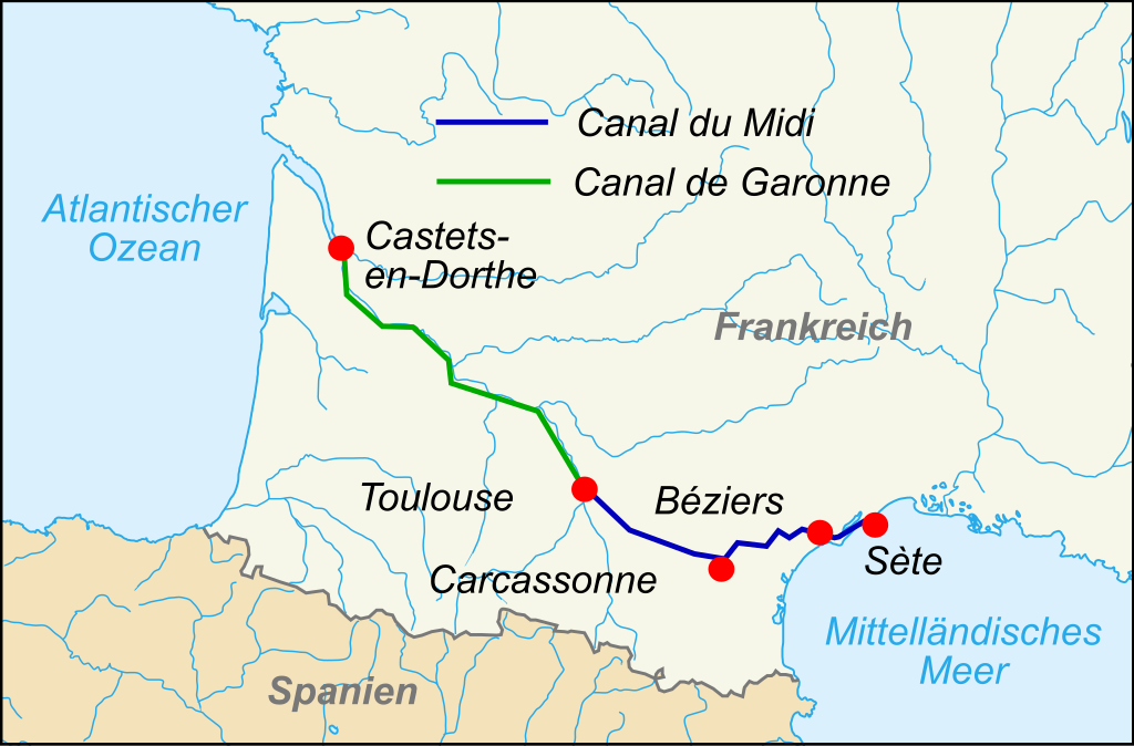
Deutsch: Verlauf des Canal du Midi in Frankreich
Français : Carte en svg du canal du Midi en France ; texte en français
English: SVG map of Canal du Midi in France; french text |
||
| Date | (UTC) | ||
| Source |
This file was derived from: Canal du Midi map-fr.svg: |
||
| Author |
|
||
| SVG development | This W3C-invalid map was created with Adobe Illustrator, and with Inkscape.
|
Licensing edit
I, the copyright holder of this work, hereby publish it under the following licenses:
This file is licensed under the Creative Commons Attribution-Share Alike 3.0 Unported, 2.5 Generic, 2.0 Generic and 1.0 Generic license.
- You are free:
- to share – to copy, distribute and transmit the work
- to remix – to adapt the work
- Under the following conditions:
- attribution – You must give appropriate credit, provide a link to the license, and indicate if changes were made. You may do so in any reasonable manner, but not in any way that suggests the licensor endorses you or your use.
- share alike – If you remix, transform, or build upon the material, you must distribute your contributions under the same or compatible license as the original.

|
Permission is granted to copy, distribute and/or modify this document under the terms of the GNU Free Documentation License, Version 1.2 or any later version published by the Free Software Foundation; with no Invariant Sections, no Front-Cover Texts, and no Back-Cover Texts. A copy of the license is included in the section entitled GNU Free Documentation License. |
You may select the license of your choice.
Original upload log edit
This image is a derivative work of the following images:
- File:Canal du Midi map-fr.svg licensed with Cc-by-sa-3.0,2.5,2.0,1.0, GFDL
- 2010-03-07T19:50:58Z Pinpin 1047x689 (404872 Bytes)
- 2007-10-06T14:36:03Z Pinpin 1047x689 (403969 Bytes) cadrage
- 2007-10-06T14:31:30Z Pinpin 1047x840 (403973 Bytes) {{Information |Description={{en|SVG map of Canal du Midi in France; french text}} {{fr|Carte en svg du canal du Midi en France ; texte en français}} |Source=Own work made with Inkscape from [[:Image:France blank.svg]] and [[
Uploaded with derivativeFX
File history
Click on a date/time to view the file as it appeared at that time.
| Date/Time | Thumbnail | Dimensions | User | Comment | |
|---|---|---|---|---|---|
| current | 14:04, 26 February 2012 | | 1,047 × 689 (551 KB) | Furfur (talk | contribs) | == {{int:filedesc}} == {{Information |Description={{de|Verlauf des Canal du Midi in Frankreich}} {{fr|Carte en svg du canal du Midi en France ; texte en français}} {{en|SVG map of Canal du Midi in France; french text}} |Source={{Derived from|Canal_du_... |
You cannot overwrite this file.
File usage on Commons
There are no pages that use this file.
File usage on other wikis
The following other wikis use this file:
- Usage on de.wikipedia.org
- Usage on tr.wikipedia.org