File:Cantabros.png
No higher resolution available.
Cantabros.png (763 × 519 pixels, file size: 141 KB, MIME type: image/png)
Captions
Captions
Add a one-line explanation of what this file represents
| Description |
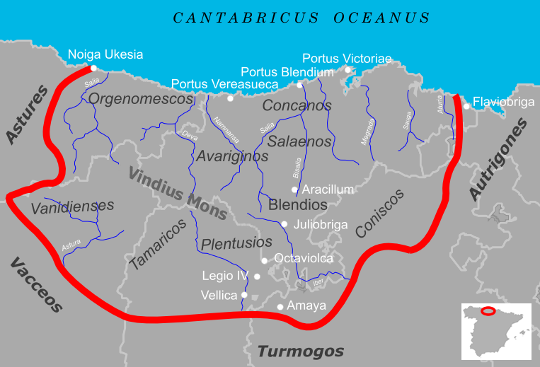
Español: Cantabria durante el periodo de las Guerras Cántabras. El mapa señala las fronteras del territorio cántabro en relación con la Cantabria actual así como las distintas tribus que lo habitaban, los pueblos vecinos, ciudades y accidentes geográficos interpretados a partir de fuentes clásicas.
English: Roman Cantabria during the Cantabrian Wars. The map indicates the borders of the cantabrian territory in relation to the present Cantabria as well as the different tribes who inhabited it, the neighboring people, towns and geographic features. |
| Date | |
| Source | Own work |
| Author | Emilio Gómez Fernández |
Summary edit
- Title
Español: Mapa de la Cantabria Antigua
English: Map of the ancient Cantabria
- Created with:
Inkscape
Licensing edit
I, the copyright holder of this work, hereby publish it under the following licenses:

|
Permission is granted to copy, distribute and/or modify this document under the terms of the GNU Free Documentation License, Version 1.2 or any later version published by the Free Software Foundation; with no Invariant Sections, no Front-Cover Texts, and no Back-Cover Texts. A copy of the license is included in the section entitled GNU Free Documentation License. |
| This file is licensed under the Creative Commons Attribution-Share Alike 3.0 Unported license. | ||
| ||
| This licensing tag was added to this file as part of the GFDL licensing update. |
This file is licensed under the Creative Commons Attribution 2.5 Generic license.
- You are free:
- to share – to copy, distribute and transmit the work
- to remix – to adapt the work
- Under the following conditions:
- attribution – You must give appropriate credit, provide a link to the license, and indicate if changes were made. You may do so in any reasonable manner, but not in any way that suggests the licensor endorses you or your use.
You may select the license of your choice.
File history
Click on a date/time to view the file as it appeared at that time.
| Date/Time | Thumbnail | Dimensions | User | Comment | |
|---|---|---|---|---|---|
| current | 20:50, 23 September 2005 | | 763 × 519 (141 KB) | Tony Rotondas (talk | contribs) | *'''Title''' {{Spanish}} Mapa de la Cantabria antigua <br /> {{English}} Map of the ancient Cantabria<br /> *'''Description''' {{Spanish}} Cantabria romana durante el periodo de las Guerras Cántabras. El mapa señala las fronteras del territorio cánt |
| 11:40, 7 May 2005 |  | 763 × 519 (292 KB) | Tony Rotondas (talk | contribs) |
You cannot overwrite this file.
File usage on Commons
The following page uses this file:
File usage on other wikis
The following other wikis use this file:
- Usage on es.wikipedia.org