File:Cantons-belfort-2015.jpg

Original file (2,724 × 1,892 pixels, file size: 5.44 MB, MIME type: image/jpeg)
Captions
Captions
Summary edit
| Description |
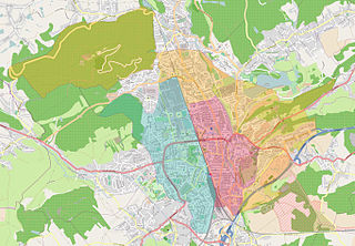
This file was uploaded with Commonist. Carte des cantons de la commune de Belfort, suite au redécoupage cantonal de 2014 entrant en vigueur en 2015 selon le décret n° 2014-155 du 13 février 2014 portant délimitation des cantons dans le département du Territoire de Belfort :
Une carte dynamique est disponible ici : http://umap.openstreetmap.fr/fr/map/cantons-belfortains_29001#14/47.6480/6.8442 Une carte officielle est disponible ici : http://www.cg90.fr/lassemblee-departementale/carte-cantonale-du-territoire-de-belfort |
||||||||||||||||||||||
| Date | |||||||||||||||||||||||
| Source | You may find a page on the OpenStreetMap wiki page for Carte des cantons de la commune de Belfort | ||||||||||||||||||||||
| Creator |
OpenStreetMap contributors, OpenStreetMap contributors
|
||||||||||||||||||||||
| Permission (Reusing this file) |
OpenStreetMap data is available under the Open Database License (details). Map tiles are licensed under the Creative Commons Attribution-ShareAlike 2.0 license (CC-BY-SA 2.0).
This file is licensed under the Creative Commons Attribution-Share Alike 2.0 Generic license.
|
||||||||||||||||||||||
| Georeferencing | If inappropriate please set warp_status = skip to hide. | ||||||||||||||||||||||

File history
Click on a date/time to view the file as it appeared at that time.
| Date/Time | Thumbnail | Dimensions | User | Comment | |
|---|---|---|---|---|---|
| current | 18:27, 16 March 2015 | | 2,724 × 1,892 (5.44 MB) | ComputerHotline (talk | contribs) | |
| 07:12, 11 March 2015 |  | 2,724 × 1,892 (5.43 MB) | ComputerHotline (talk | contribs) | ||
| 08:36, 18 February 2015 |  | 2,724 × 1,892 (5.39 MB) | ComputerHotline (talk | contribs) |
You cannot overwrite this file.
File usage on Commons
There are no pages that use this file.
File usage on other wikis
The following other wikis use this file:
- Usage on fr.wikipedia.org