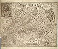
File:Capt John Smith's map of Virginia 1624.jpg

Original file (2,520 × 1,944 pixels, file size: 1.02 MB, MIME type: image/jpeg)
Captions
Captions
Summary edit
| Title |
A Map of Virginia: With a Description of the Countrey, the Commodities, People, Government and Religion |
|||||||||
| Map legend |
Discovered and discribed by Captaijn John Smith 1606. Graven by William Hole. |
|||||||||
| Date |
|
|||||||||
| Source | ||||||||||
| Creator |
William Hole (engraver, d. 1624) |
|||||||||
| Permission (Reusing this file) |
|
|||||||||
| Geotemporal data | ||||||||||
| Date depicted |
|
|||||||||
| Map location |
Virginia, United States |
|||||||||
| Map type |
Historical map |
|||||||||
| Bounding box |
|
|||||||||
| Georeferencing | View the georeferenced map in the Wikimaps Warper | |||||||||
| Bibliographic data | ||||||||||
| Publication |
A Map of Virginia: With a Description of the Countrey, the Commodities, People, Government and Religion |
|||||||||
| Author |
Captain John Smith |
|||||||||
| Language |
English |
|||||||||
| Place of publication |
Oxford |
|||||||||
| Publisher |
Joseph Barnes |
|||||||||
| Archival data | ||||||||||
| Dimensions |
height: 32 cm (12.5 in); width: 41 cm (16.1 in) dimensions QS:P2048,32U174728 dimensions QS:P2049,41U174728
|
|||||||||
| Medium | engraving on paper | |||||||||
Licensing edit
| Public domainPublic domainfalsefalse |
|
This work is in the public domain in its country of origin and other countries and areas where the copyright term is the author's life plus 100 years or fewer. | |
| This file has been identified as being free of known restrictions under copyright law, including all related and neighboring rights. | |
https://creativecommons.org/publicdomain/mark/1.0/PDMCreative Commons Public Domain Mark 1.0falsefalse
File history
Click on a date/time to view the file as it appeared at that time.
| Date/Time | Thumbnail | Dimensions | User | Comment | |
|---|---|---|---|---|---|
| current | 00:24, 20 June 2011 |  | 2,520 × 1,944 (1.02 MB) | Frank Schulenburg (talk | contribs) | Source: http://www.virtualjamestown.org/maps1.html |
| 20:03, 16 June 2010 |  | 1,000 × 849 (242 KB) | MarmadukePercy (talk | contribs) | {{Information |Description={{en|1=John Smith's map of Virginia from "The Generall Historie of Virginia, New-England, and the Summer Isles," published in London, 1624. Courtesy of University of North Carolina Libraries.}} |Source=http://www.learnnc.org/lp/ |
You cannot overwrite this file.
File usage on Commons
There are no pages that use this file.
File usage on other wikis
The following other wikis use this file:
- Usage on en.wikipedia.org
- Usage on fr.wikipedia.org
- Usage on fy.wikipedia.org
- Usage on he.wikipedia.org
- Usage on hy.wikipedia.org
- Usage on incubator.wikimedia.org
- Usage on it.wikipedia.org
- Usage on la.wikipedia.org
Metadata
This file contains additional information such as Exif metadata which may have been added by the digital camera, scanner, or software program used to create or digitize it. If the file has been modified from its original state, some details such as the timestamp may not fully reflect those of the original file. The timestamp is only as accurate as the clock in the camera, and it may be completely wrong.
| _error | 0 |
|---|