File:Capture of Menagh airbase by IS and Syrian rebels (2013).jpg

Size of this preview: 800 × 473 pixels. Other resolutions: 320 × 189 pixels | 640 × 378 pixels | 1,264 × 747 pixels.
Original file (1,264 × 747 pixels, file size: 86 KB, MIME type: image/jpeg)
Captions
Captions
Add a one-line explanation of what this file represents
Summary edit
| Description |
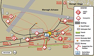
English: This map shows the siege and fall of Menagh airbase, in Syria, in August 2013. |
|||
| Date | ||||
| Source |
 |
|||
| Author | US Army | |||
| Permission (Reusing this file) |
|
|||
| Other versions | https://commons.wikimedia.org/wiki/File:Legend_for_Tactical_Diagrams.tiff |

.jpg&action=edit§ion=1)
File history
Click on a date/time to view the file as it appeared at that time.
| Date/Time | Thumbnail | Dimensions | User | Comment | |
|---|---|---|---|---|---|
| current | 02:39, 12 March 2018 | | 1,264 × 747 (86 KB) | Streamline8988 (talk | contribs) | {{Information |description ={{en|1=This map shows the siege and fall of Menagh airbase, in Syria, in August 2013.}} |source =Threat Tactics Report: Islamic State of Iraq and the Levant |author =US Army |date =Nov 2014 |permission ={{PD-USGov-Military-Army}} |other versions=https://commons.wikimedia.org/wiki/File:Legend_for_Tactical_Diagrams.tiff }} Category:Maps Category:Syrian Civil War |
You cannot overwrite this file.
File usage on Commons
The following page uses this file:
File usage on other wikis
The following other wikis use this file:
- Usage on en.wikipedia.org
- Usage on fr.wikipedia.org
- Usage on pt.wikipedia.org
.jpg&oldid=848062876)