File:Cardiff city centre basic map.jpg
Size of this preview: 800 × 519 pixels. Other resolutions: 320 × 208 pixels | 640 × 415 pixels | 815 × 529 pixels.
Original file (815 × 529 pixels, file size: 63 KB, MIME type: image/jpeg)
Captions
Captions
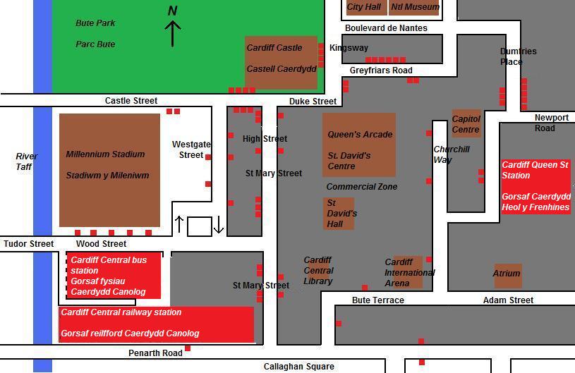
A basic map of the major motor vehicle routes around the city centre of Cardiff, Wales.
Summary edit
| Description |
English: A very basic map showing the main streets (and bus routes) in Cardiff city centre. This map is by no means to scale and many smaller streets have been omitted. Brown denotes an attraction, red denotes a transport building or structure, green denotes parkland, blue denotes a river and grey denotes commercial area. |
| Date | |
| Source | Own work (Original text: I created this work entirely by myself.) |
| Author | Welshleprechaun (talk) |
Licensing edit
| This work has been released into the public domain by its author, Welshleprechaun at English Wikipedia. This applies worldwide. In some countries this may not be legally possible; if so: Welshleprechaun grants anyone the right to use this work for any purpose, without any conditions, unless such conditions are required by law. |
Original upload log edit
Transferred from en.wikipedia to Commons by Liftarn using CommonsHelper.
The original description page was here. All following user names refer to en.wikipedia.
- 2009-05-07 00:07 Welshleprechaun 815×529× (65009 bytes) Font colour changed to make more visible
- 2009-05-07 00:00 Welshleprechaun 815×529× (62326 bytes) {{Information |Description = A very basic map showing the main streets (and bus routes) in [[Cardiff]] city centre. This map is by no means to scale and many smaller streets have been omitted. Brown denotes an attraction, red denotes a transport build

|
This city map image could be re-created using vector graphics as an SVG file. This has several advantages; see Commons:Media for cleanup for more information. If an SVG form of this image is available, please upload it and afterwards replace this template with
{{vector version available|new image name}}.
It is recommended to name the SVG file “Cardiff city centre basic map.svg”—then the template Vector version available (or Vva) does not need the new image name parameter. |

File history
Click on a date/time to view the file as it appeared at that time.
| Date/Time | Thumbnail | Dimensions | User | Comment | |
|---|---|---|---|---|---|
| current | 13:11, 1 December 2010 | | 815 × 529 (63 KB) | File Upload Bot (Magnus Manske) (talk | contribs) | {{BotMoveToCommons|en.wikipedia|year={{subst:CURRENTYEAR}}|month={{subst:CURRENTMONTHNAME}}|day={{subst:CURRENTDAY}}}} {{Information |Description={{en|A very basic map showing the main streets (and bus routes) in en:Cardiff city centre. This map is |
You cannot overwrite this file.
File usage on Commons
There are no pages that use this file.