File:Carta das Comunicacoes de Tras-os-Montes - GazetaCF 1290 1941.jpg

Size of this preview: 800 × 552 pixels. Other resolutions: 320 × 221 pixels | 640 × 442 pixels | 1,024 × 707 pixels | 1,192 × 823 pixels.
Original file (1,192 × 823 pixels, file size: 660 KB, MIME type: image/jpeg)
Captions
Captions
Add a one-line explanation of what this file represents
Summary edit
| Description |
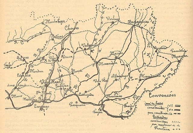
Português: Mapa da região de Trás-os-Montes, em Portugal, mostrando as vias de comunicação terrestres já construídas e projectadas.
Esta fotografia foi publicada na Gazeta dos Caminhos de Ferro n.º 1290, de 1 de Setembro de 1941, e digitalizada pela Hemeroteca Municipal de Lisboa.
English: Map of the Trás-os-Montes region, in Portugal, showing the built and projected road and rail routes.
This photograph was published on the Gazeta dos Caminhos de Ferro magazine No. 1290, of 1st September 1941, and scanned by the Hemeroteca Municipal de Lisboa. |
| Date | |
| Source | http://hemerotecadigital.cm-lisboa.pt/OBRAS/GazetaCF/1941/N1290/N1290_item1/P29.html |
| Author | Unknown author |
Licensing edit
This image (or other media file) is in the public domain because its copyright has expired and its author is anonymous.
This applies to the European Union and those countries with a copyright term of 70 years after the work was made available to the public and the author never disclosed their identity. Important: Always mention where the image comes from, as far as possible, and make sure the author never claimed authorship. |
 | |
 |
Note: In Germany and possibly other countries, certain anonymous works published before July 1, 1995 are copyrighted until 70 years after the death of the author. See Übergangsrecht. Please use this template only if the author never claimed authorship or their authorship never became public in any other way. If the work is anonymous or pseudonymous (e.g., published only under a corporate or organization's name), use this template for images published more than 70 years ago.
For a work made available to the public in the United Kingdom, please use Template:PD-UK-unknown instead.
|
File history
Click on a date/time to view the file as it appeared at that time.
| Date/Time | Thumbnail | Dimensions | User | Comment | |
|---|---|---|---|---|---|
| current | 21:49, 12 March 2016 | | 1,192 × 823 (660 KB) | Ajpvalente (talk | contribs) | User created page with UploadWizard |
You cannot overwrite this file.
File usage on Commons
The following 5 pages use this file:
- User:Chumwa/OgreBot/Potential transport maps/2016 March 11-20
- User:Chumwa/OgreBot/Public transport information/2016 March 11-20
- User:Chumwa/OgreBot/Transport Maps/2016 March 11-20
- User:Chumwa/OgreBot/Travel and communication maps/2016 March 11-20
- User:Jcornelius/Portugal Public Transport/2016 March 11-20
File usage on other wikis
The following other wikis use this file:
- Usage on it.wikipedia.org
- Usage on pt.wikipedia.org