File:Carte des aqueducs romains de Lyon par Artaud d'après Delorme.jpg

Size of this preview: 403 × 599 pixels. Other resolutions: 161 × 240 pixels | 323 × 480 pixels | 516 × 768 pixels | 688 × 1,024 pixels | 1,377 × 2,048 pixels | 4,518 × 6,718 pixels.
Original file (4,518 × 6,718 pixels, file size: 3.93 MB, MIME type: image/jpeg)
Captions
Captions
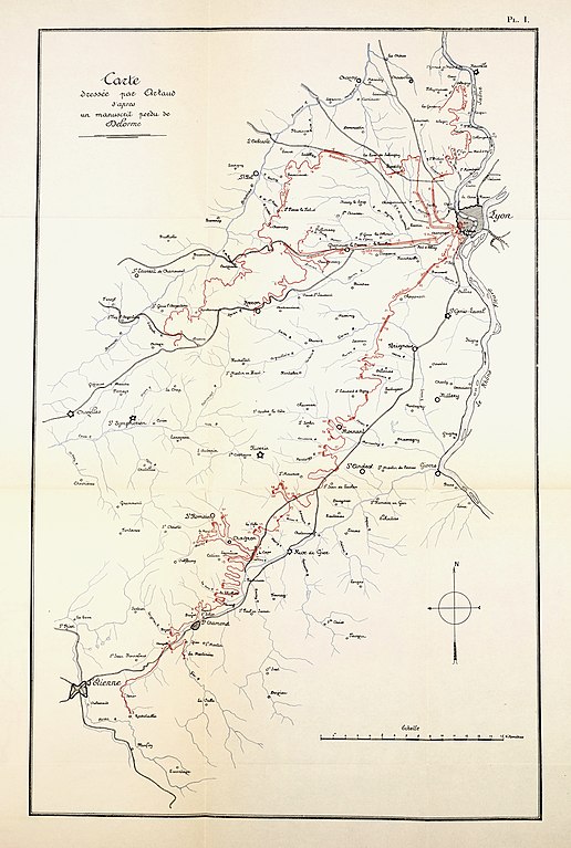
Map of the Roman aqueducts of Lyon, drawn by François Artaud in 1817 from a lost manuscript by Guillaume Marie Delorme
Summary edit
| Description |
Français : Cette carte est extraite de l'ouvrage de Camille Germain de Montauzan intitulé "Les aqueducs antiques de Lyon : étude comparée d'archéologie romaine", Ernest Leroux éditeur, Paris, 1909. |
| Date | |
| Source | numelyo / Bibliothèque municipale de Lyon : https://numelyo.bm-lyon.fr/f_view/BML:BML_00GOO0100137001104312140/IMG00000483 |
| Author | François Artaud (1767-1838) |
Licensing edit
| This file is made available under the Creative Commons CC0 1.0 Universal Public Domain Dedication. | |
| The person who associated a work with this deed has dedicated the work to the public domain by waiving all of their rights to the work worldwide under copyright law, including all related and neighboring rights, to the extent allowed by law. You can copy, modify, distribute and perform the work, even for commercial purposes, all without asking permission.
|
File history
Click on a date/time to view the file as it appeared at that time.
| Date/Time | Thumbnail | Dimensions | User | Comment | |
|---|---|---|---|---|---|
| current | 11:15, 19 December 2022 | | 4,518 × 6,718 (3.93 MB) | Naboton (talk | contribs) | Uploaded a work by François Artaud (1767-1838) from https://numelyo.bm-lyon.fr/f_view/BML:BML_00GOO0100137001104312140/IMG00000483 with UploadWizard |
You cannot overwrite this file.
File usage on Commons
There are no pages that use this file.
File usage on other wikis
The following other wikis use this file:
- Usage on fr.wikipedia.org