File:Carte du cours du fleuve de St. Laurent depuis son embouchure jusqu'au dessus de Quebec, pour servir à l'Histoire générale des voyages. LOC 73697069.jpg

Size of this preview: 800 × 538 pixels. Other resolutions: 320 × 215 pixels | 640 × 430 pixels | 1,024 × 689 pixels | 1,280 × 861 pixels | 2,560 × 1,721 pixels | 4,481 × 3,013 pixels.
Original file (4,481 × 3,013 pixels, file size: 1.9 MB, MIME type: image/jpeg)
Captions
Captions
Add a one-line explanation of what this file represents
Summary edit
| Description |
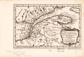
English: Scale ca. 1:2,850,000. Relief shown pictorially. "Tom XIV, in 4⁰, no. 15. Tome 14, in 8⁰, page 254, no. 1." Appears in Jean Francois de La Harpe's Abrégé de l'histoire generale des voyages. 1780. LC Maps of North America, 1750-1789, 229 Vault AACR2 |
||
| Title | Carte du cours du fleuve de St. Laurent depuis son embouchure jusqu'au dessus de Quebec, pour servir à l'Histoire générale des voyages. | ||
| Shelf ID | G3312.S5 1757 .B42 | ||
| Date | |||
| Source | https://www.loc.gov/item/73697069/ | ||
| Author | Bellin, Jacques Nicolas | ||
| Permission (Reusing this file) |
|
||
| Other versions |
|
||
| Location | Saint Lawrence River · North America | ||
| Part of | Military Battles And Campaigns · American Memory · Catalog · Geography And Map Division · American Revolution And Its Era: Maps And Charts Of North America And The West Indies, 1750-1789 | ||
| Subject | Saint Lawrence River · Maps · Early Works To 1800 · North America |

Licensing edit
|
This is a faithful photographic reproduction of a two-dimensional, public domain work of art. The work of art itself is in the public domain for the following reason:
The official position taken by the Wikimedia Foundation is that "faithful reproductions of two-dimensional public domain works of art are public domain".
This photographic reproduction is therefore also considered to be in the public domain in the United States. In other jurisdictions, re-use of this content may be restricted; see Reuse of PD-Art photographs for details. | ||||
File history
Click on a date/time to view the file as it appeared at that time.
| Date/Time | Thumbnail | Dimensions | User | Comment | |
|---|---|---|---|---|---|
| current | 00:18, 5 August 2018 | | 4,481 × 3,013 (1.9 MB) | Fæ (talk | contribs) | LOC Maps https://www.loc.gov/item/73697069/ #22399 |
You cannot overwrite this file.
File usage on Commons
The following page uses this file: