File:Castle Roy - geograph.org.uk - 301716.jpg
No higher resolution available.
Castle_Roy_-_geograph.org.uk_-_301716.jpg (640 × 480 pixels, file size: 92 KB, MIME type: image/jpeg)
Captions
Captions
Add a one-line explanation of what this file represents
Summary edit
| Description |
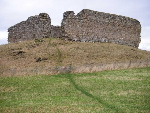
English: Castle Roy Castle Roy, or Redcastle, a 13th century fortress, seen from a small car park on the Nethy to Grantown road (B970). The castle is unsafe and there is no public access to it.
A notice at the car park informs you that the castle stands on a rocky hummock which has probably been artificially altered to improve the defences. The castle consists of a courtyard measuring 24m by 16m with the remains of a tower in the north angle (furthest from you). The walls are about 2m thick and 6 - 7m high, built from rubble held together with a strong lime mortar. The castle was simply a high wall and tower protecting those within the courtyard who lived in wooden lean-to buildings against the walls. |
| Date | |
| Source | From geograph.org.uk |
| Author | Roy Turnbull |
| Attribution (required by the license) | Roy Turnbull / Castle Roy / |
| Camera location | | View this and other nearby images on: OpenStreetMap |
|---|
_heading:0.00&language=en)
| Object location | | View this and other nearby images on: OpenStreetMap |
|---|
_heading:0.00&language=en)
Licensing edit

|
This image was taken from the Geograph project collection. See this photograph's page on the Geograph website for the photographer's contact details. The copyright on this image is owned by Roy Turnbull and is licensed for reuse under the Creative Commons Attribution-ShareAlike 2.0 license.
|
This file is licensed under the Creative Commons Attribution-Share Alike 2.0 Generic license.
Attribution: Roy Turnbull
- You are free:
- to share – to copy, distribute and transmit the work
- to remix – to adapt the work
- Under the following conditions:
- attribution – You must give appropriate credit, provide a link to the license, and indicate if changes were made. You may do so in any reasonable manner, but not in any way that suggests the licensor endorses you or your use.
- share alike – If you remix, transform, or build upon the material, you must distribute your contributions under the same or compatible license as the original.
File history
Click on a date/time to view the file as it appeared at that time.
| Date/Time | Thumbnail | Dimensions | User | Comment | |
|---|---|---|---|---|---|
| current | 21:32, 22 December 2010 | | 640 × 480 (92 KB) | GeographBot (talk | contribs) | == {{int:filedesc}} == {{Information |description={{en|1=Castle Roy Castle Roy, or Redcastle, a 13th century fortress, seen from a small car park on the Nethy to Grantown road (B970). The castle is unsafe and there is no public access to it. A notice at |
You cannot overwrite this file.
File usage on Commons
There are no pages that use this file.
File usage on other wikis
The following other wikis use this file:
- Usage on en.wikipedia.org