File:Cavitt Creek Falls Recreation Site (32561062980).jpg

Original file (2,578 × 1,916 pixels, file size: 3.91 MB, MIME type: image/jpeg)
Captions
Captions
Summary edit
.jpg&action=edit§ion=1)
| Description |
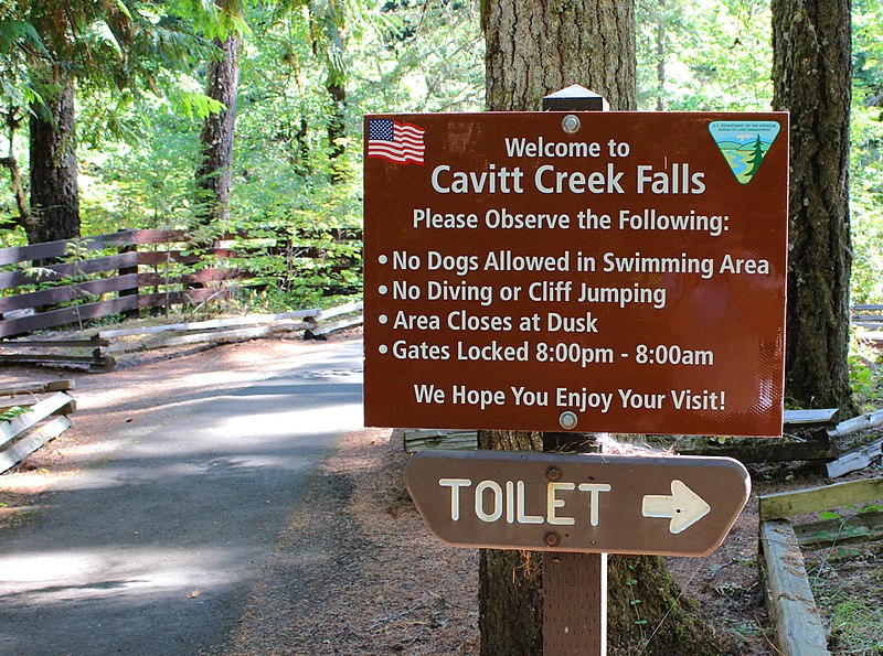
Looking for a great spot to cool down on those hot summer days? Grab your swimming gear and head to Cavitt Creek Campground and day-use area. This site is best known for its swimming hole at the base of a series of small waterfalls and jumping salmon and steelhead in the fall and winter. For more adventure, head to the nearby Wolf Creek Falls Trail for a 1.2 mile walk to the view the 75’ tall Wolf Creek Falls. Being away from the busier North Umpqua River corridor, Cavitt Creek proves you don’t have to travel far to get off the beaten path. Know Before You Go: •Campground has 10 non-reservable campsites. •Overnight camping fee is $10/per night. Check-in time is 1:00pm and check-out time is 11:00am. •Pets are not allowed in the swimming area but are allowed in the campground. They must be kept on a 6-foot leash or shorter. •The day-use area is open from 8am to 8pm. •The campground is typically open from late-May to late-September. Directions: To get there, go 16.5 miles east of Roseburg on Highway 138, turn right on Little River Road and proceed for 6.7 miles. Turn right at the covered bridge on Cavitt Creek Road and continue for 3.2 miles to Cavitt Creek Falls Recreation Site. To Wolf Creek Falls Trailhead, travel back down Cavitt Creek Rd to Little River Rd. Turn right and follow Little River Road for 4 miles to the trailhead on the right. Point of Interest: Cavitt Creek and nearby Little River are open to trout fishing with artificial flies and lures only. Closed for salmon and steelhead. See current Oregon Department of Fish and Wildlife fishing regulations for details. Contact: BLM Roseburg District, 777 NW Garden Valley Blvd, Roseburg, OR 97471 or 541-440-4930 <a href="https://www.blm.gov/visit" rel="nofollow">www.blm.gov/visit</a> |
| Date | |
| Source | Cavitt Creek Falls Recreation Site |
| Author | Bureau of Land Management Oregon and Washington from Portland, America |
Licensing edit
.jpg&action=edit§ion=2)
- You are free:
- to share – to copy, distribute and transmit the work
- to remix – to adapt the work
- Under the following conditions:
- attribution – You must give appropriate credit, provide a link to the license, and indicate if changes were made. You may do so in any reasonable manner, but not in any way that suggests the licensor endorses you or your use.
| This image was originally posted to Flickr by BLMOregon at https://flickr.com/photos/50169152@N06/32561062980 (archive). It was reviewed on 13 May 2018 by FlickreviewR 2 and was confirmed to be licensed under the terms of the cc-by-2.0. |
| This image is a work of a Bureau of Land Management* employee, taken or made as part of that person's official duties. As a work of the U.S. federal government, the image is in the public domain in the United States. *or predecessor organization |
USGov files uploaded by OceanAtoll
| This image is a work of a Bureau of Land Management* employee, taken or made as part of that person's official duties. As a work of the U.S. federal government, the image is in the public domain in the United States. *or predecessor organization |
File history
Click on a date/time to view the file as it appeared at that time.
| Date/Time | Thumbnail | Dimensions | User | Comment | |
|---|---|---|---|---|---|
| current | 23:51, 13 May 2018 | | 2,578 × 1,916 (3.91 MB) | OceanAtoll (talk | contribs) | Transferred from Flickr via #flickr2commons |
You cannot overwrite this file.
File usage on Commons
There are no pages that use this file.
.jpg&oldid=851958165)