File:Cayambe Equator monument 02.jpg

Size of this preview: 376 × 599 pixels. Other resolutions: 151 × 240 pixels | 301 × 480 pixels | 482 × 768 pixels | 643 × 1,024 pixels | 1,286 × 2,048 pixels | 2,579 × 4,106 pixels.
Original file (2,579 × 4,106 pixels, file size: 4.14 MB, MIME type: image/jpeg)
Captions
Captions
Add a one-line explanation of what this file represents
Summary edit
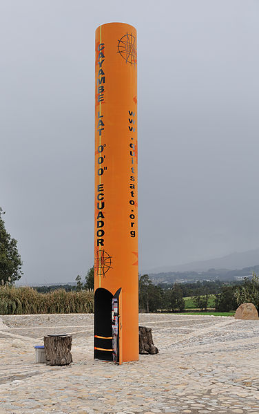
| Description |
English: Ecuador: Sundial exactly positioned on the equator line near the town of Cayambe. Altitude: 2747 m. The equator is the lighter line that runs through the column. The site is managed by a non governmental organization of volunteers.
Español: Ecuador: columna cilíndrica posicionada exactamente en la línea ecuatorial, cerca de la villa de Cayambe. Altitud: 2747 m. El ecuador es la línea de color más claro que atraviesa la columna. El sitio es gestionado por una organización no gubernamental de voluntarios.
Français : Équateur : cylindre, fonctionnant comme horloge solaire, placé exactement sur l'Équateur : ligne de l'équateur près de la ville de Cayambe au pied du volcan Cayambe. L'équateur est la ligne pavée claire qui traverse la colonne. Altitude : 2747 m. Le site est géré par une association non gouvernementale de bénévoles. |
| Date | |
| Source | Own work |
| Author | Cayambe |
| Other versions |
|


This image has been assessed using the Quality image guidelines and is considered a Quality image.
|
Licensing edit
I, the copyright holder of this work, hereby publish it under the following licenses:
This file is licensed under the Creative Commons Attribution-Share Alike 3.0 Unported license.
- You are free:
- to share – to copy, distribute and transmit the work
- to remix – to adapt the work
- Under the following conditions:
- attribution – You must give appropriate credit, provide a link to the license, and indicate if changes were made. You may do so in any reasonable manner, but not in any way that suggests the licensor endorses you or your use.
- share alike – If you remix, transform, or build upon the material, you must distribute your contributions under the same or compatible license as the original.

|
Permission is granted to copy, distribute and/or modify this document under the terms of the GNU Free Documentation License, Version 1.2 or any later version published by the Free Software Foundation; with no Invariant Sections, no Front-Cover Texts, and no Back-Cover Texts. A copy of the license is included in the section entitled GNU Free Documentation License. |
You may select the license of your choice.
File history
Click on a date/time to view the file as it appeared at that time.
| Date/Time | Thumbnail | Dimensions | User | Comment | |
|---|---|---|---|---|---|
| current | 15:28, 21 October 2010 | | 2,579 × 4,106 (4.14 MB) | Cayambe (talk | contribs) | {{Information |Description={{en|1=Ecuador: Sundial exactly positioned on the equator line near the town of Cayambe. Altitude: 2747 m. The equator is the lighter line that runs through the column. The site is managed by a non governmental o |
You cannot overwrite this file.
File usage on Commons
The following 7 pages use this file:
- User:Cayambe/Ecuador
- User:Cayambe/Ecuador/Quito
- User talk:Cayambe/Archive 2010
- Commons:Quality images/Subject/Places/Man made structures/Buildings, Exterior/Part 1a
- Commons:Quality images candidates/Archives October 2010
- Commons talk:Quality images/Subject/Places/Man made structures
- File:Cayambe Equator monument 01.jpg
File usage on other wikis
The following other wikis use this file:
- Usage on fr.wikipedia.org
- Usage on uk.wikipedia.org