File:Central banat ethnic2002.png

Size of this preview: 442 × 600 pixels. Other resolutions: 177 × 240 pixels | 354 × 480 pixels | 740 × 1,004 pixels.
Original file (740 × 1,004 pixels, file size: 62 KB, MIME type: image/png)
Captions
Captions
Add a one-line explanation of what this file represents
Summary edit
| Description |
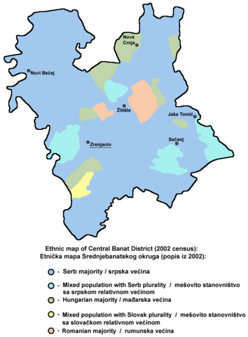
English: Ethnic map of Central Banat District - 2002 census (data by settlements). Serbian: Етничка мапа Средњебанатског округа - попис из 2002 (подаци по насељима). |
| Source | Own work |
| Author | PANONIAN |
References edit
- Popis stanovništva, domaćinstava i stanova u 2002., Stanovništvo, nacionalna ili etnička pripadnost - Podaci po naseljima, knjiga 1, Republika Srbija - Republički zavod za statistiku, Beograd, februar 2003.
- Slobodan Radovanović, Geografski atlas, Magic Map, Smederevska Palanka, 2001.
- Školski geografski atlas, Intersistem Kartografija, Beograd, 2004.
- Denis Šehić - Demir Šehić, Geografski atlas Srbije, Beograd, 2007.
- http://commons.wikimedia.org/wiki/File:Census_2002_Serbia,_ethnic_map_(by_localities).png
.png)
Licensing edit
| I, the copyright holder of this work, release this work into the public domain. This applies worldwide. In some countries this may not be legally possible; if so: I grant anyone the right to use this work for any purpose, without any conditions, unless such conditions are required by law. |
File history
Click on a date/time to view the file as it appeared at that time.
| Date/Time | Thumbnail | Dimensions | User | Comment | |
|---|---|---|---|---|---|
| current | 20:01, 15 April 2011 | | 740 × 1,004 (62 KB) | PANONIAN (talk | contribs) | aesthetics |
| 20:44, 15 October 2009 |  | 740 × 1,004 (62 KB) | PANONIAN (talk | contribs) | {{Information |Description={{en|1=Ethnic map of Central Banat District - 2002 census.<br>'''Serbian:''' Етничка мапа Средњебанатског округа - попис из 2002. }} |Source={{own}} |Author=PANONIAN |Date |
You cannot overwrite this file.
File usage on Commons
The following page uses this file:
File usage on other wikis
The following other wikis use this file:
- Usage on ca.wikipedia.org
- Usage on en.wikipedia.org
- Usage on gl.wikipedia.org
- Usage on hr.wikipedia.org
- Usage on hu.wikipedia.org
- Usage on ja.wikipedia.org
- Usage on ko.wikipedia.org
- Usage on mk.wikipedia.org
- Usage on sco.wikipedia.org
- Usage on sh.wikipedia.org
- Usage on sr.wikipedia.org