File:CenturyLink Arena, Boise, Idaho (22417067393).jpg
Original file (4,000 × 3,000 pixels, file size: 3.43 MB, MIME type: image/jpeg)
Captions
Captions
Summary edit
.jpg&action=edit§ion=1)
| Description |
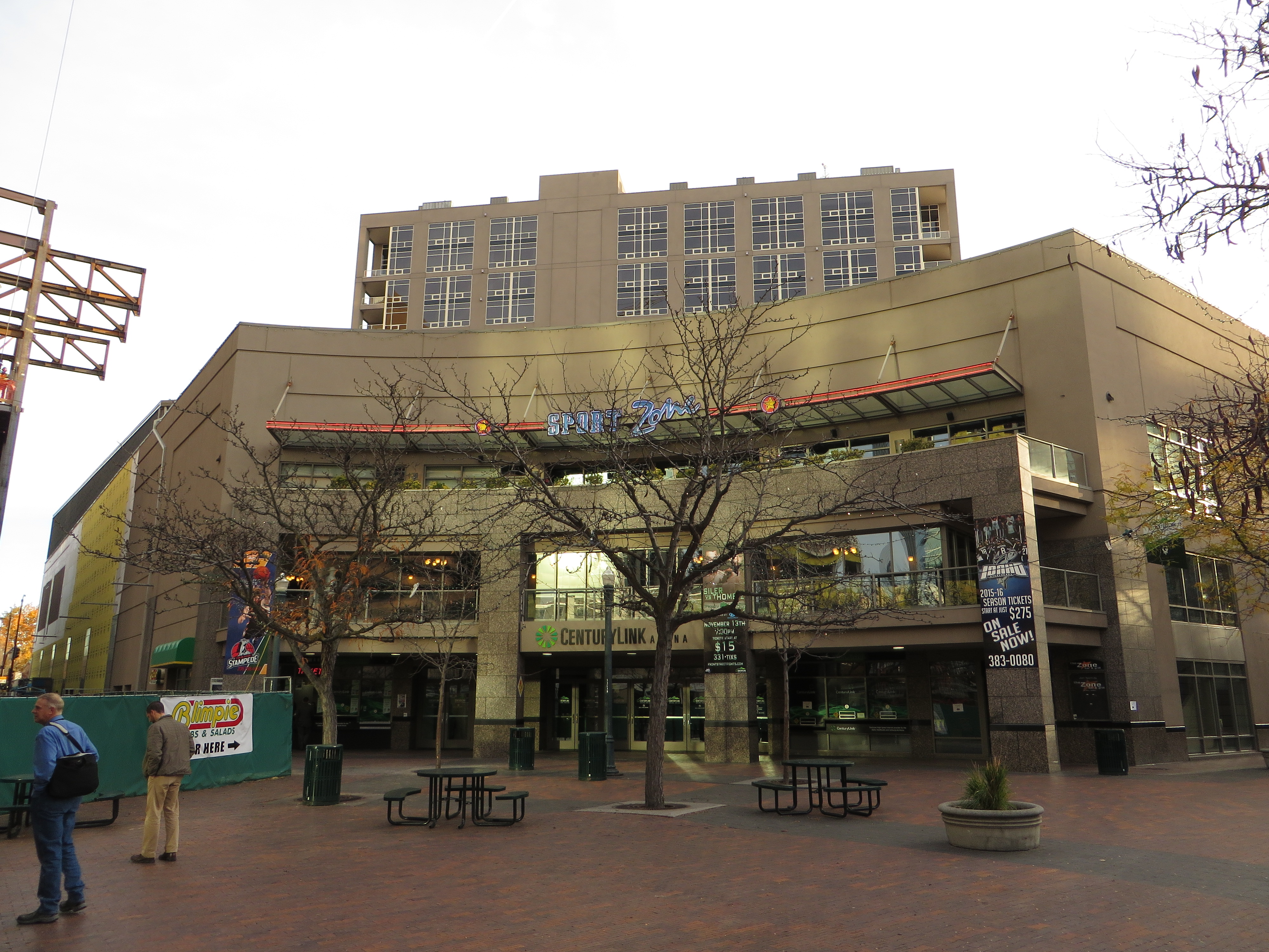
CenturyLink Arena (formerly Qwest Arena, originally Bank of America Centre) is a multi-purpose arena in the western United States, located in Boise, Idaho. Its seating capacity is 5,002 for ice hockey, 5,300 for basketball, 5,732 for end-stage concerts, 6,400 for boxing, and up to 6,800 for center-stage concerts. With 4,508 permanent seats, it was built for $50 million. In downtown Boise, its street level elevation is approximately 2,700 feet (825 m) above sea level. Opened 21 years ago, it has been the home arena of the Idaho Steelheads of the ECHL since 1997. Other tenants include the Boise Stallions of the Indoor Professional Football League in 2000 and 2001, the Idaho Stampede of the NBA Development League from 2005 to 2016, and the Boise Burn of the af2 from 2007 to 2009. With CenturyLink's takeover of Qwest Communications in 2011, the venue was renamed CenturyLink Arena Boise on August 18. Originally the Bank of America Centre, it became Qwest Arena in 2005. <a href="https://en.wikipedia.org/wiki/CenturyLink_Arena" rel="noreferrer nofollow">en.wikipedia.org/wiki/CenturyLink_Arena</a> <a href="https://en.wikipedia.org/wiki/Wikipedia:Text_of_Creative_Commons_Attribution-ShareAlike_3.0_Unported_License" rel="noreferrer nofollow">en.wikipedia.org/wiki/Wikipedia:Text_of_Creative_Commons_...</a> |
| Date | |
| Source | CenturyLink Arena, Boise, Idaho |
| Author | Ken Lund from Reno, Nevada, USA |
| Camera location | | View this and other nearby images on: OpenStreetMap |
|---|
.jpg¶ms=043.615544_N_-116.204362_E_globe:Earth_type:camera_source:Flickr_&language=en)
Licensing edit
.jpg&action=edit§ion=2)
- You are free:
- to share – to copy, distribute and transmit the work
- to remix – to adapt the work
- Under the following conditions:
- attribution – You must give appropriate credit, provide a link to the license, and indicate if changes were made. You may do so in any reasonable manner, but not in any way that suggests the licensor endorses you or your use.
- share alike – If you remix, transform, or build upon the material, you must distribute your contributions under the same or compatible license as the original.
| This image was originally posted to Flickr by Ken Lund at https://flickr.com/photos/75683070@N00/22417067393 (archive). It was reviewed on 26 April 2019 by FlickreviewR 2 and was confirmed to be licensed under the terms of the cc-by-sa-2.0. |
File history
Click on a date/time to view the file as it appeared at that time.
| Date/Time | Thumbnail | Dimensions | User | Comment | |
|---|---|---|---|---|---|
| current | 01:34, 26 April 2019 | | 4,000 × 3,000 (3.43 MB) | SecretName101 (talk | contribs) | Transferred from Flickr via #flickr2commons |
You cannot overwrite this file.
File usage on Commons
The following page uses this file:
File usage on other wikis
The following other wikis use this file:
- Usage on sv.wikipedia.org
.jpg&oldid=853175898)