File:Ceredigion Coast Path, a less trodden section - geograph.org.uk - 998665.jpg

Size of this preview: 450 × 600 pixels. Other resolutions: 180 × 240 pixels | 480 × 640 pixels.
Original file (480 × 640 pixels, file size: 198 KB, MIME type: image/jpeg)
Captions
Captions
Add a one-line explanation of what this file represents
Summary edit
| Description |
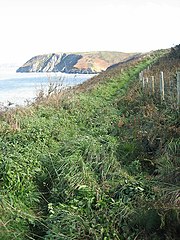
English: Ceredigion Coast Path: a less trodden section After Pen-Peles point, the path going east appears more overgrown and less frequented. It had only been open two months or less when this image was taken and it may be that walkers from Mwnt turn back at 998628. By doing this, they miss a dramatic view of the 998271 and a magical wooded valley 998270 but also some really muddy stretches! 1000781 |
| Date | |
| Source | From geograph.org.uk |
| Author | Zorba the Geek |
| Attribution (required by the license) | Zorba the Geek / Ceredigion Coast Path: a less trodden section / |
| Camera location | | View this and other nearby images on: OpenStreetMap |
|---|
_heading:112.00&language=en)
| Object location | | View this and other nearby images on: OpenStreetMap |
|---|
_heading:112.00&language=en)
Licensing edit

|
This image was taken from the Geograph project collection. See this photograph's page on the Geograph website for the photographer's contact details. The copyright on this image is owned by Zorba the Geek and is licensed for reuse under the Creative Commons Attribution-ShareAlike 2.0 license.
|
This file is licensed under the Creative Commons Attribution-Share Alike 2.0 Generic license.
Attribution: Zorba the Geek
- You are free:
- to share – to copy, distribute and transmit the work
- to remix – to adapt the work
- Under the following conditions:
- attribution – You must give appropriate credit, provide a link to the license, and indicate if changes were made. You may do so in any reasonable manner, but not in any way that suggests the licensor endorses you or your use.
- share alike – If you remix, transform, or build upon the material, you must distribute your contributions under the same or compatible license as the original.

|
The categories of this image need checking. You can do so here.
|
File history
Click on a date/time to view the file as it appeared at that time.
| Date/Time | Thumbnail | Dimensions | User | Comment | |
|---|---|---|---|---|---|
| current | 03:40, 23 February 2011 | | 480 × 640 (198 KB) | GeographBot (talk | contribs) | == {{int:filedesc}} == {{Information |description={{en|1=Ceredigion Coast Path: a less trodden section After Pen-Peles point, the path going east appears more overgrown and less frequented. It had only been open two months or less when this image was tak |
You cannot overwrite this file.
File usage on Commons
There are no pages that use this file.