File:Chalkidiki - DEM Map Topo - DE.png
Size of this preview: 800 × 500 pixels. Other resolutions: 320 × 200 pixels | 640 × 400 pixels | 1,024 × 640 pixels | 1,280 × 801 pixels | 2,072 × 1,296 pixels.
Original file (2,072 × 1,296 pixels, file size: 1.42 MB, MIME type: image/png)
Captions
Captions
Halkidiki
Summary edit
| Description |
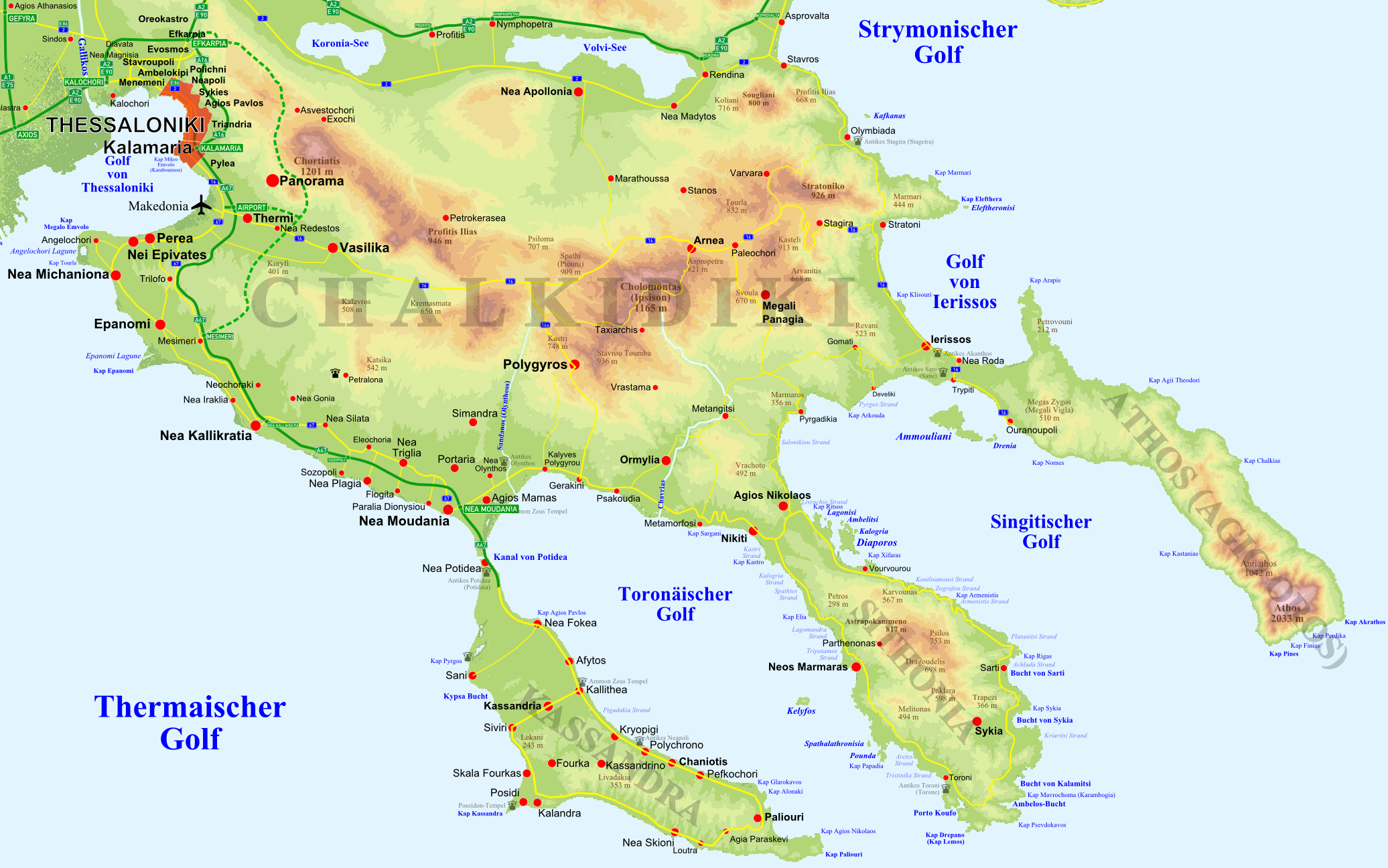
Deutsch: Topographische Karte der Halbinsel w:de:Chalkidiki in w:de:Griechenland ergänzt um Straßen, Ortschaften und Bezeichnungen. English: Topographic Map of w:Chalkidiki peninsula, w:Greece, supplemented with roads, settlements, topographic designations |
| Date | |
| Source | Own work |
| Author | Christaras A |
| Other versions |
 |
Licensing edit
I, the copyright holder of this work, hereby publish it under the following licenses:
This file is licensed under the Creative Commons Attribution-Share Alike 3.0 Unported license.
- You are free:
- to share – to copy, distribute and transmit the work
- to remix – to adapt the work
- Under the following conditions:
- attribution – You must give appropriate credit, provide a link to the license, and indicate if changes were made. You may do so in any reasonable manner, but not in any way that suggests the licensor endorses you or your use.
- share alike – If you remix, transform, or build upon the material, you must distribute your contributions under the same or compatible license as the original.

|
Permission is granted to copy, distribute and/or modify this document under the terms of the GNU Free Documentation License, Version 1.2 or any later version published by the Free Software Foundation; with no Invariant Sections, no Front-Cover Texts, and no Back-Cover Texts. A copy of the license is included in the section entitled GNU Free Documentation License. |
You may select the license of your choice.
File history
Click on a date/time to view the file as it appeared at that time.
| Date/Time | Thumbnail | Dimensions | User | Comment | |
|---|---|---|---|---|---|
| current | 14:44, 10 May 2008 | | 2,072 × 1,296 (1.42 MB) | Christaras A (talk | contribs) | == Summary == {{Information |Description={{de|Topographische Karte der Halbinsel w:de:Chalkidiki in w:de:Griechenland ergänzt um Straßen, Ortschaften und Bezeichnungen.}}<br/>{{en|Topographic Map of w:Chalkidiki peninsula, w:Greece, supp |
You cannot overwrite this file.
File usage on Commons
The following 3 pages use this file:
File usage on other wikis
The following other wikis use this file:
- Usage on az.wikipedia.org
- Usage on be.wikipedia.org
- Usage on bg.wikipedia.org
- Usage on ca.wikipedia.org
- Usage on de.wikipedia.org
- Usage on el.wikipedia.org
- Usage on es.wikipedia.org
- Usage on et.wikipedia.org
- Usage on fi.wikipedia.org
- Usage on fr.wikipedia.org
- Usage on he.wikipedia.org
- Usage on hu.wikipedia.org
- Usage on it.wikipedia.org
- Usage on ja.wikipedia.org
- Usage on mk.wikipedia.org
- Usage on pl.wiktionary.org
- Usage on ru.wikipedia.org
- Usage on uk.wikipedia.org
- Usage on www.wikidata.org