File:Chantilly cornfield.jpg

Size of this preview: 800 × 532 pixels. Other resolutions: 320 × 213 pixels | 640 × 426 pixels | 1,024 × 681 pixels | 1,280 × 851 pixels | 2,560 × 1,702 pixels | 6,016 × 4,000 pixels.
Original file (6,016 × 4,000 pixels, file size: 6.44 MB, MIME type: image/jpeg)
Captions
Captions
Add a one-line explanation of what this file represents
|
This is an image of a place or building that is listed on the National Register of Historic Places in the United States of America. Its reference number is 71000990. |
| Camera location | | View this and other nearby images on: OpenStreetMap |
|---|
| Description |
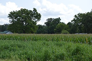
English: Fields on the western end of what was once the Chantilly plantation, seen looking east from Independence Drive just east of Stratford Hall in Westmoreland County, Virginia, United States. The plantation site is listed on the National Register of Historic Places. |
||
| Date | Taken on 26 August 2017 | ||
| Source | Own work | ||
| Author | Nyttend | ||
| Permission (Reusing this file) |
|
File history
Click on a date/time to view the file as it appeared at that time.
| Date/Time | Thumbnail | Dimensions | User | Comment | |
|---|---|---|---|---|---|
| current | 00:44, 11 September 2017 | | 6,016 × 4,000 (6.44 MB) | Nyttend (talk | contribs) | {{NRHP|71000990}} {{Location|38|9|14|N|76|58|17|W}} {{Information |Description={{en|Fields on the western end of what was once the {{w|Chantilly}} plantation, seen looking east from Independence Drive just east of {{w|Stratford Hall (plantation)|Stratf... |
You cannot overwrite this file.
File usage on Commons
There are no pages that use this file.
File usage on other wikis
The following other wikis use this file:
- Usage on en.wikipedia.org
- Usage on www.wikidata.org