File:Chart and plan of the harbour of New York and the couny. adjacent, from Sandy Hook to Kingsbridge - comprehending the whole of New York and Staten Islands, and part of Long Island and the Jersey NYPL434626.tiff

Size of this JPG preview of this TIF file: 375 × 599 pixels. Other resolutions: 150 × 240 pixels | 300 × 480 pixels | 481 × 768 pixels | 641 × 1,024 pixels | 1,282 × 2,048 pixels | 4,896 × 7,822 pixels.
Original file (4,896 × 7,822 pixels, file size: 109.57 MB, MIME type: image/tiff)
Captions
Captions
Add a one-line explanation of what this file represents
Summary edit
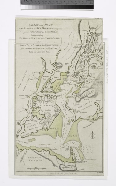
| Description | Chart and plan of the harbour of New York and the couny. adjacent, from Sandy Hook to Kingsbridge : comprehending the whole of New York and Staten Islands, and part of Long Island and the Jersey shore, and shewing the defences of New York both by land and sea / Jno. Lodge, sculp.; Cartographic materials from the Emmet Collection of Manuscripts Etc. Relating to American History. | |||||||||||||||||||||||
| Notes | Relief shown by hachures. Depths shown by soundings. ''Note 2.'') National Endowment for the Humanities Grant for Access to Early Maps of the Middle Atlantic Seaboard. ''Note 3.'') In upper right corner: Political Mage. Novr. 1781. ''Note 4.'') Emmet Collection ; 10917. | |||||||||||||||||||||||
| Item physical description | 1 map : hand col. ; 42 x 25 cm. | |||||||||||||||||||||||
| Catalogue call number | Map Div. 00-448 | |||||||||||||||||||||||
| Standard reference | Phillips. Maps of America, p. 528; EM10917; Haskell, D.C. Manhattan maps, 534 | |||||||||||||||||||||||
| Date | ||||||||||||||||||||||||
| Source |
http://digitalgallery.nypl.org/nypldigital/dgkeysearchdetail.cfm?imageID=434626
|
|||||||||||||||||||||||
| Author | Lodge, John, d. 1796 -- Engraver | |||||||||||||||||||||||
| Permission (Reusing this file) |
From The Lionel Pincus and Princess Firyal Map Division. http://maps.nypl.org
|
|||||||||||||||||||||||
| Location | Stephen A. Schwarzman Building / The Lionel Pincus and Princess Firyal Map Division | |||||||||||||||||||||||
| Digital item published | 2-3-2004; updated 3-25-2011 | |||||||||||||||||||||||
| Digital ID | 434626 | |||||||||||||||||||||||

The making of this file was supported by Wikimedia UK.
To see other files made with the support of Wikimedia UK, please see the category Supported by Wikimedia UK.
|
File history
Click on a date/time to view the file as it appeared at that time.
| Date/Time | Thumbnail | Dimensions | User | Comment | |
|---|---|---|---|---|---|
| current | 19:17, 26 April 2014 |  | 4,896 × 7,822 (109.57 MB) | Fæ (talk | contribs) | GWToolset:: Creating mediafile for Fæ. Tranche 3 5495-7474 |
You cannot overwrite this file.
File usage on Commons
There are no pages that use this file.