File:Chateau de Gaillon Le Rouge 1750.jpg

Size of this preview: 800 × 565 pixels. Other resolutions: 320 × 226 pixels | 640 × 452 pixels | 1,024 × 724 pixels | 1,280 × 905 pixels | 2,560 × 1,809 pixels | 3,860 × 2,728 pixels.
Original file (3,860 × 2,728 pixels, file size: 6.01 MB, MIME type: image/jpeg)
Captions
Captions
Add a one-line explanation of what this file represents
| Description |
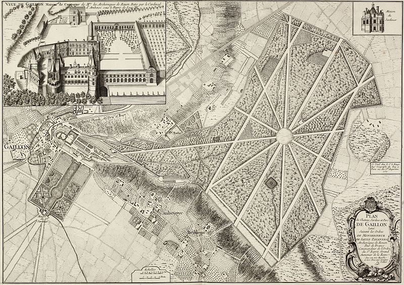
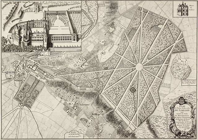
Deutsch: Stich mit einer Ansicht und einem Plan des Schlosses Gaillon Français : «Plan du château, jardins et parc de Gaillon», dessin de Le Tellier. |
||||||||||||||||||||||
| Date | |||||||||||||||||||||||
| Source | http://www.vintage-maps.com/de/Antike-Landkarten/Europa/Frankreich/le-Rouge-Frankreich-Gaillon-Gartenplan-1750::957.html | ||||||||||||||||||||||
| Author |
|
||||||||||||||||||||||
|
This work is in the public domain in its country of origin and other countries and areas where the copyright term is the author's life plus 100 years or fewer. | |
| This file has been identified as being free of known restrictions under copyright law, including all related and neighboring rights. | |
File history
Click on a date/time to view the file as it appeared at that time.
| Date/Time | Thumbnail | Dimensions | User | Comment | |
|---|---|---|---|---|---|
| current | 12:54, 10 November 2010 | | 3,860 × 2,728 (6.01 MB) | Sir Gawain (talk | contribs) | {{Information |Description={{de|Stich mit einer Ansicht und einem Plan des Schlosses Gaillon}} |Source=http://www.vintage-maps.com/de/Antike-Landkarten/Europa/Frankreich/le-Rouge-Frankreich-Gaillon-Gartenplan-1750::957.html |Date=1750 |Author= George Loui |
You cannot overwrite this file.
File usage on Commons
There are no pages that use this file.
File usage on other wikis
The following other wikis use this file:
- Usage on es.wikipedia.org
- Usage on fr.wikipedia.org