File:Cherkasy province location map.svg

Size of this PNG preview of this SVG file: 533 × 447 pixels. Other resolutions: 286 × 240 pixels | 572 × 480 pixels | 916 × 768 pixels | 1,221 × 1,024 pixels | 2,442 × 2,048 pixels.
Original file (SVG file, nominally 533 × 447 pixels, file size: 137 KB)
Captions
Captions
Add a one-line explanation of what this file represents
Summary edit
| Description |
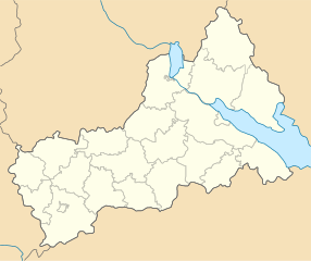
English: Location map of Cherkasy province, Ukraine
Русский: Позиционная карта Черкасской области, Украина
Українська: Карта Черкаської області, Україна |
| Date | |
| Source | Own work |
| Author | Urutseg |
| SVG development | This locator map was created with Inkscape. |
Licensing edit
| I, the copyright holder of this work, release this work into the public domain. This applies worldwide. In some countries this may not be legally possible; if so: I grant anyone the right to use this work for any purpose, without any conditions, unless such conditions are required by law. |
File history
Click on a date/time to view the file as it appeared at that time.
| Date/Time | Thumbnail | Dimensions | User | Comment | |
|---|---|---|---|---|---|
| current | 09:29, 29 June 2014 | | 533 × 447 (137 KB) | קרלוס הגדול (talk | contribs) | lighter borders between provinces |
| 18:30, 6 December 2010 |  | 533 × 447 (137 KB) | Urutseg (talk | contribs) |
You cannot overwrite this file.
File usage on Commons
The following page uses this file:
File usage on other wikis
The following other wikis use this file:
- Usage on ar.wikipedia.org
- Usage on be.wikipedia.org
- Чаркасы
- Умань
- Тальнэ
- Сміла
- Хрыстыніўка
- Шрамкіўка
- Шаблон:На карце/Украіна Чаркаская вобласць
- Звэныгародка
- Букы
- Вэрхнячка
- Еркы
- Катэрынопіль
- Цыбуліў
- Манькіўка
- Лысянка
- Цвітковэ
- Стэбліў
- Сэмэніўка (Лысянскі раён)
- Навасілка (Манастырышчэнскі раён)
- Ямпіль (Катэрынопільскі раён)
- Чэрэпын (Корсунь-Шэўчэнкіўскі раён)
- Навэ Міста (Манастырышчэнскі раён)
- Usage on bg.wikipedia.org
- Usage on ceb.wikipedia.org
- Usage on de.wikipedia.org
- Usage on es.wikipedia.org
- Usage on fa.wikipedia.org
- Usage on he.wikipedia.org
View more global usage of this file.