File:China DNI Solar-resource-map lang-CN GlobalSolarAtlas World-Bank-Esmap-Solargis.png

Original file (1,842 × 1,802 pixels, file size: 2.13 MB, MIME type: image/png)
Captions
Captions
Summary edit
| Description |
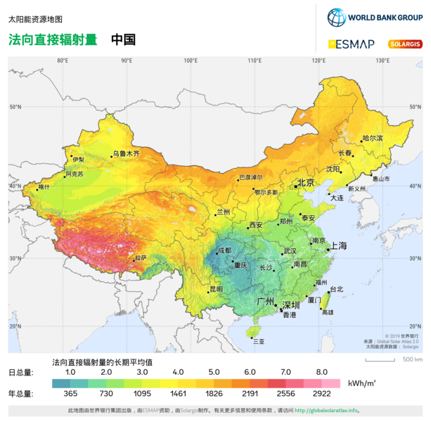
中文:太阳能资源:法向直接辐射量 (DNI) - 此地图概述了可用于发电和其他能源应用的预估太阳能。展示了法向直接辐射量 (DNI) 年/日总量的长期平均值。基础太阳能资源数据库由 Solargis 模型根据大气和卫星数据计算得出,时间步长为 15 或 30 分钟。DNI 是聚光太阳能 (CSP) 和聚光太阳能光伏 (CPV) 技术发电量计算和性能评估的最重要参数,此图考虑了地形影响,标称空间分辨率为 250 米。DNI 对于计算倾斜或太阳追踪光伏模块所接收的总辐照量同样意义重大。更多详情请访问:https://globalsolaratlas.info。
English: Solar resource: DIRECT NORMAL IRRADIATION (DNI) - this map provides a summary of the estimated solar energy available for power generation and other energy applications. It represents the long-term average of daily/yearly totals of direct normal irradiation (DNI). The underlying solar resource database is calculated by the Solargis model from atmospheric and satellite data with 15- or 30-minute time step. The effects of terrain are considered at nominal spatial resolution of 250 m. DNI is the most important parameter for energy yield calculation and performance assessment of concentrating solar power (CSP) and concentrator solar photovoltaic (CPV) technologies. DNI is also important for the calculation of global irradiation received by tilted or sun-tracking photovoltaic modules. Further details available at: https://globalsolaratlas.info. |
| Date | |
| Source | https://globalsolaratlas.info/downloads |
| Author | Solargis |
| Attribution (required by the license) | © The World Bank, Source: Global Solar Atlas 2.0, Solar resource data: Solargis / |
The World Bank Group has published this solar resource map using data from the Global Solar Atlas (GSA), to support the scale-up of solar power in our client countries. This work is funded by the Energy Sector Management Assistance Program (ESMAP), a multi-donor trust fund administered by The World Bank and supported by 18 donor partners. It is part of a global ESMAP initiative on Renewable Energy Resource Mapping that covers biomass, hydropower, solar and wind. This map has been prepared by Solargis, under contract to The World Bank, based on a solar resource database that Solargis owns and maintains. To obtain additional maps and information, please visit: http://globalsolaratlas.info.
Licensing edit
- You are free:
- to share – to copy, distribute and transmit the work
- to remix – to adapt the work
- Under the following conditions:
- attribution – You must give appropriate credit, provide a link to the license, and indicate if changes were made. You may do so in any reasonable manner, but not in any way that suggests the licensor endorses you or your use.
File history
Click on a date/time to view the file as it appeared at that time.
| Date/Time | Thumbnail | Dimensions | User | Comment | |
|---|---|---|---|---|---|
| current | 14:58, 19 March 2021 | | 1,842 × 1,802 (2.13 MB) | SolarSoft (talk | contribs) | Uploaded own work with UploadWizard |
You cannot overwrite this file.
File usage on Commons
There are no pages that use this file.