File:Christopher Columbus voyages map-fr.svg

Size of this PNG preview of this SVG file: 800 × 523 pixels. Other resolutions: 320 × 209 pixels | 640 × 418 pixels | 1,024 × 669 pixels | 1,280 × 836 pixels | 2,560 × 1,673 pixels | 1,922 × 1,256 pixels.
Original file (SVG file, nominally 1,922 × 1,256 pixels, file size: 399 KB)
Captions
Captions
Add a one-line explanation of what this file represents
Summary edit
| Description |
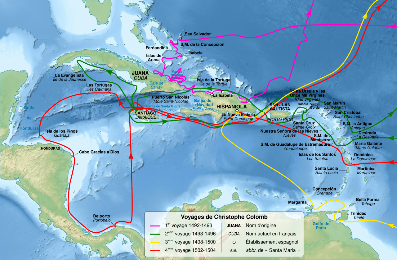
English: Map of Christopher Columbus voyages, between 1492 and 1504. Français : Carte des voyages de Christophe Colomb, entre 1492 et 1504. Equirectangular projection, WGS84 datum
Geographic limits of the map:
|
||
| Date | |||
| Source |
Own work. Sources : Data :
|
||
| Author | Sémhur (talk) | ||
| Other versions |
Derivative works of this file: Christopher Colombus first voyage 1492-1493 map-fr.svg | ||
| Attribution (required by the license) | © Sémhur / Wikimedia Commons / | ||
| SVG | W3C-validity not checked.
|
||
| Graphic Lab |

| Camera location | | View this and other nearby images on: OpenStreetMap |
|---|
Licensing edit
I, the copyright holder of this work, hereby publish it under the following licenses:
| Copyleft: This work of art is free; you can redistribute it and/or modify it according to terms of the Free Art License. You will find a specimen of this license on the Copyleft Attitude site as well as on other sites. |
This file is licensed under the Creative Commons Attribution-Share Alike 4.0 International, 3.0 Unported, 2.5 Generic, 2.0 Generic and 1.0 Generic license.
- You are free:
- to share – to copy, distribute and transmit the work
- to remix – to adapt the work
- Under the following conditions:
- attribution – You must give appropriate credit, provide a link to the license, and indicate if changes were made. You may do so in any reasonable manner, but not in any way that suggests the licensor endorses you or your use.
- share alike – If you remix, transform, or build upon the material, you must distribute your contributions under the same or compatible license as the original.
You may select the license of your choice.
File history
Click on a date/time to view the file as it appeared at that time.
| Date/Time | Thumbnail | Dimensions | User | Comment | |
|---|---|---|---|---|---|
| current | 10:56, 18 February 2011 | | 1,922 × 1,256 (399 KB) | Sémhur (talk | contribs) | Increase text size |
| 21:28, 13 February 2011 |  | 1,922 × 1,256 (356 KB) | Sémhur (talk | contribs) | == {{int:filedesc}} == {{Information |Description={{Multilingual description |en=Map of Christopher Columbus voyages, between 1492 and 1504. |fr=Carte des voyages de Christophe Colomb, entre 1492 et 1 |
You cannot overwrite this file.
File usage on Commons
The following page uses this file:
File usage on other wikis
The following other wikis use this file:
- Usage on bo.wikipedia.org
- Usage on fr.wikipedia.org
- Christophe Colomb
- Découverte et exploration de l'Amérique
- Wikipédia:Atelier graphique/Cartes/Archives/février 2011
- Modèle:Infobox Événement historique
- Modèle:Infobox Événement historique/Documentation
- Colonisation espagnole de l'Amérique
- Utilisateur:Ambre Troizat/Todo/Exposition 10 mai 94120 2013
- Histoire des Caraïbes
- Usage on fr.wikisource.org
- Usage on fr.wikiversity.org
- Usage on hu.wikipedia.org
- Usage on incubator.wikimedia.org