File:Chrzanow quarters.svg

Size of this PNG preview of this SVG file: 432 × 415 pixels. Other resolutions: 250 × 240 pixels | 500 × 480 pixels | 799 × 768 pixels | 1,066 × 1,024 pixels | 2,132 × 2,048 pixels.
Original file (SVG file, nominally 432 × 415 pixels, file size: 220 KB)
Captions
Captions
Add a one-line explanation of what this file represents
Summary edit
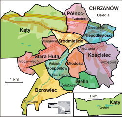
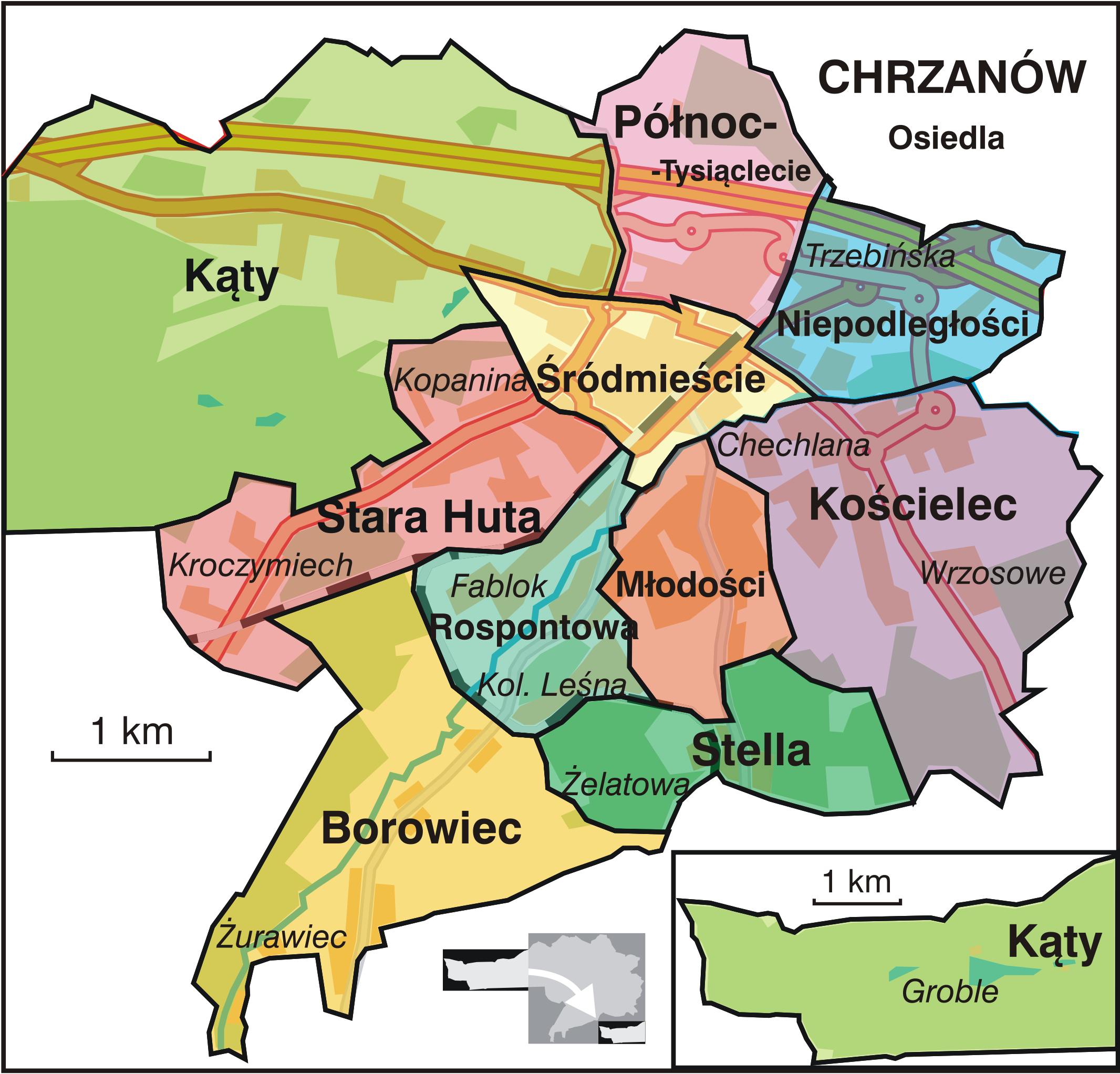
| Description | Map of administrative quarters in the town of Chrzanow, Poland |
| Date | |
| Source | Own work |
| Author | Obbie |
Licensing edit
| This work has been released into the public domain by its author, I, Obbie. This applies worldwide. In some countries this may not be legally possible; if so: I, Obbie grants anyone the right to use this work for any purpose, without any conditions, unless such conditions are required by law. |
File history
Click on a date/time to view the file as it appeared at that time.
| Date/Time | Thumbnail | Dimensions | User | Comment | |
|---|---|---|---|---|---|
| current | 22:02, 3 November 2012 | | 432 × 415 (220 KB) | Musp (talk | contribs) | aktualizacja dróg |
| 23:35, 2 November 2012 |  | 432 × 415 (205 KB) | Musp (talk | contribs) | poprawa nazwy osiedla z Północ-Tysiąclecia na Północ-Tysiąclecie | |
| 14:36, 23 August 2008 |  | 432 × 415 (180 KB) | Obbie (talk | contribs) | {{Information |Description=Map of administrative quarters in the town of Chrzanow, Poland |Source=self-made |Date=Aug 23, 2008 |Author= Obbie }} Category:Maps of Chrzanów | |
| 17:37, 29 July 2007 |  | 432 × 415 (171 KB) | Obbie (talk | contribs) | {{Information |Description=Map of administrative quarters in the town of Chrzanow, Poland |Source=self-made |Date=Jul 29, 2007 |Author= Obbie }} | |
| 14:29, 29 July 2007 |  | 432 × 415 (173 KB) | Obbie (talk | contribs) | {{Information |Description=Map of administrative quarters in the town of Chrzanow, Poland |Source=self-made |Date=Jul 29, 2007 |Author= Obbie }} |
You cannot overwrite this file.
File usage on Commons
The following 7 pages use this file:
File usage on other wikis
The following other wikis use this file:
- Usage on ar.wikipedia.org
- Usage on arz.wikipedia.org
- Usage on bg.wikipedia.org
- Usage on ca.wikipedia.org
- Usage on de.wikipedia.org
- Usage on el.wikipedia.org
- Usage on es.wikipedia.org
- Usage on eu.wikipedia.org
- Usage on fo.wikipedia.org
- Usage on ga.wikipedia.org
- Usage on la.wikipedia.org
- Usage on pl.wikipedia.org
- Usage on ro.wikipedia.org
- Usage on vi.wikipedia.org
- Usage on www.wikidata.org