File:Cinque Ports map.svg

Size of this PNG preview of this SVG file: 800 × 525 pixels. Other resolutions: 320 × 210 pixels | 640 × 420 pixels | 1,024 × 672 pixels | 1,280 × 840 pixels | 2,560 × 1,680 pixels | 1,839 × 1,207 pixels.
Original file (SVG file, nominally 1,839 × 1,207 pixels, file size: 154 KB)
Captions
Captions
Add a one-line explanation of what this file represents
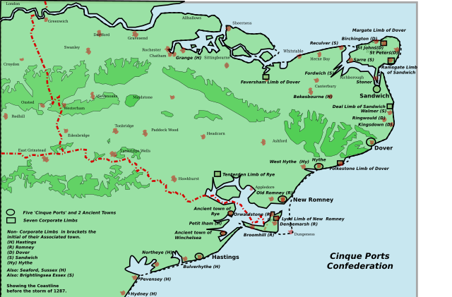
| Description | Map of the Cinque Ports in Kent and Sussex: seven port and their seven limbs and many of the associated limbs. The coastline has changed over the ages: in 1287 a storm caused the silting up of the channel of the River Rother in particular. |
| Date | (UTC) |
| Source |
Own work |
| Author |
| This is a retouched picture, which means that it has been digitally altered from its original version. Modifications: Corrected and completed county boundaries. The original can be viewed here: Kent Cinque Ports.svg:
|
I, the copyright holder of this work, hereby publish it under the following licenses:
This file is licensed under the Creative Commons Attribution 2.5 Generic license.
- You are free:
- to share – to copy, distribute and transmit the work
- to remix – to adapt the work
- Under the following conditions:
- attribution – You must give appropriate credit, provide a link to the license, and indicate if changes were made. You may do so in any reasonable manner, but not in any way that suggests the licensor endorses you or your use.
| This file is licensed under the Creative Commons Attribution-Share Alike 3.0 Unported license. | ||
| ||
| This licensing tag was added to this file as part of the GFDL licensing update. |

|
Permission is granted to copy, distribute and/or modify this document under the terms of the GNU Free Documentation License, Version 1.2 or any later version published by the Free Software Foundation; with no Invariant Sections, no Front-Cover Texts, and no Back-Cover Texts. A copy of the license is included in the section entitled GNU Free Documentation License. |
You may select the license of your choice.
Original upload log edit
This image is a derivative work of the following images:
- File:Kent_Cinque_Ports.svg licensed with Cc-by-2.5, Cc-by-sa-3.0-migrated, GFDL
- 2007-06-25T14:26:06Z ClemRutter 1839x1207 (186143 Bytes) == Summary == {{Information |Description= This ia a map of the Cinque Ports in Kent and Sussex. All seven of them and their 7 limbs and many of the associated limbs. In 1287, the storm caused the silting up of the channel of
Uploaded with derivativeFX
File history
Click on a date/time to view the file as it appeared at that time.
| Date/Time | Thumbnail | Dimensions | User | Comment | |
|---|---|---|---|---|---|
| current | 20:50, 28 September 2011 | | 1,839 × 1,207 (154 KB) | Hogweard (talk | contribs) | {{Information |Description=Map of the Cinque Ports in Kent and Sussex: seven port and their seven limbs and many of the associated limbs. The coastline has changed over the ages: in 1287 a storm caused the silting up of the channel of the River Rother in |
You cannot overwrite this file.
File usage on Commons
There are no pages that use this file.
File usage on other wikis
The following other wikis use this file:
- Usage on en.wikipedia.org
- Usage on hu.wikipedia.org
- Usage on ja.wikipedia.org
- Usage on pl.wikipedia.org