File:CisleitaniaTransleitaniaYBosniaHercegovina.svg

Size of this PNG preview of this SVG file: 776 × 600 pixels. Other resolutions: 311 × 240 pixels | 621 × 480 pixels | 994 × 768 pixels | 1,280 × 989 pixels | 2,560 × 1,978 pixels | 783 × 605 pixels.
Original file (SVG file, nominally 783 × 605 pixels, file size: 676 KB)
Captions
Captions
Add a one-line explanation of what this file represents
| Description |
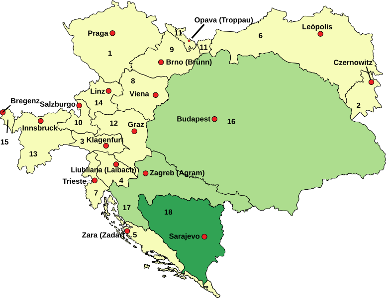
English: Austria–Hungary: Empire of Austria (Cisleithania): 1. Bohemia, 2. Bukovina, 3. Carinthia, 4. Carniola, 5. Dalmatia, 6. Galicia, 7. Küstenland, 8. Lower Austria, 9. Moravia, 10. Salzburg, 11. Silesia, 12. Styria, 13. Tyrol, 14. Upper Austria, 15. Vorarlberg; Kingdom of Hungary (Transleithania): 16. Hungary proper 17. Croatia-Slavonia; Austrian-Hungarian Co-dominion: 18. Bosnia and Herzegovina Deutsch: Österreich-Ungarn 1910: Cisleithanien: 1. Böhmen, 2. Bukowina, 3. Kärnten, 4. Krain, 5. Dalmatien, 6. Galizien, 7. Küstenland, 8. Österreich unter der Enns, 9. Mähren, 10. Salzburg, 11. Schlesien, 12. Steiermark, 13. Tirol, 14. Österreich ob der Enns, 15. Vorarlberg; Transleithanien: 16. Ungarn, 17. Kroatien und Slawonien; 18. Bosnien und Herzegowina Español: Austria–Hungría con sus dos unidades, Cisletitania y Transleitania y la provincia compartida de Bosnia.: Imperio Austriaco (Cisleitania): 1. Bohemia, 2. Bucovina, 3. Carintia, 4. Carniola, 5. Dalmacia, 6. Galicia, 7. Provincia costera 8. Baja Austria, 9. Moravia, 10. Salzburgo, 11. Silesia, 12. Estiria, 13. Tirol, 14. Alta Austria, 15. Vorarlberg; Reino de Hungría (Transleitania): 16. Hungría 17. Croacia-Eslavonia; Condomio austro-magiar: 18. Bosnia y Hercegovina |
| Date | (UTC) |
| Source | |
| Author |
|
| This is a retouched picture, which means that it has been digitally altered from its original version. Modifications: colours changed to show the 2 Imperial units and Bosnia. The original can be viewed here: Austria-Hungary map ES.svg:
|
This file is licensed under the Creative Commons Attribution-Share Alike 3.0 Unported license.
- You are free:
- to share – to copy, distribute and transmit the work
- to remix – to adapt the work
- Under the following conditions:
- attribution – You must give appropriate credit, provide a link to the license, and indicate if changes were made. You may do so in any reasonable manner, but not in any way that suggests the licensor endorses you or your use.
- share alike – If you remix, transform, or build upon the material, you must distribute your contributions under the same or compatible license as the original.
Original upload log edit
This image is a derivative work of the following images:
- File:Austria-Hungary_map_ES.svg licensed with PD-user-w
- 2010-02-11T17:35:58Z Rowanwindwhistler 783x605 (346541 Bytes) {{Information |Description={{en| '''Austria–Hungary''':'''Empire of Austria (Cisleithania)''': 1. Bohemia, 2. Bukovina, 3. Carinthia, 4. Carniola, 5. Dalmatia, 6. Galicia, 7. Küstenland, 8. Lower Austria, 9. Moravia, 10. S
Uploaded with derivativeFX
File history
Click on a date/time to view the file as it appeared at that time.
| Date/Time | Thumbnail | Dimensions | User | Comment | |
|---|---|---|---|---|---|
| current | 09:22, 29 July 2017 | | 783 × 605 (676 KB) | Rowanwindwhistler (talk | contribs) | Minor correction in text |
| 11:48, 14 July 2017 |  | 783 × 605 (620 KB) | Rowanwindwhistler (talk | contribs) | Lighter colours, hopefully easier to read. | |
| 15:59, 11 November 2016 |  | 783 × 605 (620 KB) | Rowanwindwhistler (talk | contribs) | Leópolis. Fake text added | |
| 00:39, 1 November 2010 |  | 783 × 605 (223 KB) | Rowanwindwhistler (talk | contribs) | {{Information |Description={{en| <br>'''<u>Austria–Hungary</u>''':<br>'''Empire of Austria (Cisleithania)''': 1. Bohemia, 2. Bukovina, 3. Carinthia, 4. Carniola, 5. Dalmatia, 6. Galicia, 7. Küstenland, 8. Lower Austria, 9. Moravia, 10. Salzburg, 11. Si |
You cannot overwrite this file.
File usage on Commons
The following 3 pages use this file:
File usage on other wikis
The following other wikis use this file:
- Usage on es.wikipedia.org
- Imperio austrohúngaro
- Moravia
- Compromiso austrohúngaro
- Transleitania
- Cisleitania
- Reino de Croacia-Eslavonia
- Ducado de Carintia
- Hungría durante el periodo del Compromiso austrohúngaro
- Marca de Moravia
- Austria-Hungría durante la Primera Guerra Mundial
- Organización territorial del Imperio austrohúngaro
- Usage on zh-yue.wikipedia.org