File:CityRail InterCity map.png

Size of this preview: 600 × 600 pixels. Other resolutions: 240 × 240 pixels | 480 × 480 pixels | 850 × 850 pixels.
Original file (850 × 850 pixels, file size: 99 KB, MIME type: image/png)
Captions
Captions
Add a one-line explanation of what this file represents
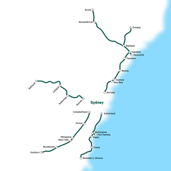
| Description | CityRail intercity and regional lines. | ||
| Date | |||
| Source | en:Image:CityRail_InterCity_map.png | ||
| Author | en:User:Joestella | ||
| Permission (Reusing this file) |
|
File history
Click on a date/time to view the file as it appeared at that time.
| Date/Time | Thumbnail | Dimensions | User | Comment | |
|---|---|---|---|---|---|
| current | 07:48, 15 April 2007 | | 850 × 850 (99 KB) | Essolo (talk | contribs) | {{Information |Description=CityRail Sydney network. |Source=en:Image:CityRail_InterCity_map.png |Date=2006/12/15 |Author=en:User:Joestella |Permission={{pd}} |other_versions= }} |
You cannot overwrite this file.
File usage on Commons
There are no pages that use this file.
File usage on other wikis
The following other wikis use this file:
- Usage on en.wikipedia.org
- Usage on en.wikibooks.org
- Usage on es.wikipedia.org
- Usage on it.wikipedia.org
- Usage on ja.wikipedia.org
- Usage on zh.wikipedia.org