File:City of New-York, and, New-York and its vicinity - drawn by D.H. Burr; engraved by S. Stiles and Co. Merhs. Exch., N.Y. NYPL446666.tiff

Size of this JPG preview of this TIF file: 642 × 600 pixels. Other resolutions: 257 × 240 pixels | 514 × 480 pixels | 822 × 768 pixels | 1,096 × 1,024 pixels | 2,193 × 2,048 pixels | 5,782 × 5,400 pixels.
Original file (5,782 × 5,400 pixels, file size: 89.34 MB, MIME type: image/tiff)
Captions
Captions
Add a one-line explanation of what this file represents
Summary edit
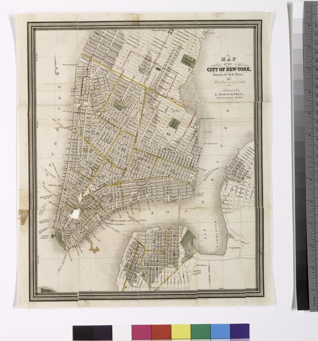
| Description | City of New-York, and, New-York and its vicinity / drawn by D.H. Burr ; engraved by S. Stiles and Co. Merhs. Exch., N.Y.; Maps of New York City and State / New York City / Manhattan | |||||||||||||||||||||||
| Notes | Relief shown by hachures. ''Note 2.'') Cover title. ''Note 3.'') [Map 2] shows boundaries, lighthouses, and railway lines. ''Note 4.'') [Map 1] Covers Manhattan up to 22nd St. on the west side and 37th St. on the east side. Also covers neighboring parts of Brooklyn and Williamsburg. [Map 2] Covers New York Metropolitan Area, including parts of New Jersey. ''Note 5.'') [Map 1]. "Entered according to Act of Congress in the year 1833, by J. Disturnell in the Clerks Office of the District Court of the Southern District of New York." -- [Map 2]. "Entered according to Act of Congress in the year 1834, by J. Disturnell in the [Clerks] Office of the District Court of the Southern District of New York." ''Note 6.'') National Endowment for the Humanities Grant for Access to Early Maps of the Middle Atlantic Seaboard. | |||||||||||||||||||||||
| Item physical description | 2 maps : hand col. ; each 30 x 25 cm., folded in leather cover 13 x 8 cm. | |||||||||||||||||||||||
| Catalogue call number | Map Div. 01-1785 [Filed flat] | |||||||||||||||||||||||
| Standard reference | Haskell, D.C. Manhattan maps, 766, 792 | |||||||||||||||||||||||
| Date | ||||||||||||||||||||||||
| Source |
http://digitalgallery.nypl.org/nypldigital/dgkeysearchdetail.cfm?imageID=446666
|
|||||||||||||||||||||||
| Author | ||||||||||||||||||||||||
| Permission (Reusing this file) |
From The Lionel Pincus and Princess Firyal Map Division. http://maps.nypl.org
|
|||||||||||||||||||||||
| Location | Stephen A. Schwarzman Building / The Lionel Pincus and Princess Firyal Map Division | |||||||||||||||||||||||
| Digital item published | 10-14-2005; updated 5-16-2012 | |||||||||||||||||||||||
| Digital ID | 446666 | |||||||||||||||||||||||

The making of this file was supported by Wikimedia UK.
To see other files made with the support of Wikimedia UK, please see the category Supported by Wikimedia UK.
|
File history
Click on a date/time to view the file as it appeared at that time.
| Date/Time | Thumbnail | Dimensions | User | Comment | |
|---|---|---|---|---|---|
| current | 22:31, 26 April 2014 |  | 5,782 × 5,400 (89.34 MB) | Fæ (talk | contribs) | GWToolset:: Creating mediafile for Fæ. Tranche 3 5495-7474 |
| 22:30, 26 April 2014 |  | 5,782 × 5,400 (89.34 MB) | Fæ (talk | contribs) | GWToolset:: Creating mediafile for Fæ. Tranche 3 5495-7474 |
You cannot overwrite this file.
File usage on Commons
There are no pages that use this file.