File:Clara Barton National Historic Site, Maryland LOC 2012585024.tif
Size of this JPG preview of this TIF file: 643 × 600 pixels. Other resolutions: 257 × 240 pixels | 515 × 480 pixels | 823 × 768 pixels | 1,098 × 1,024 pixels | 2,195 × 2,048 pixels | 5,064 × 4,724 pixels.
Original file (5,064 × 4,724 pixels, file size: 68.44 MB, MIME type: image/tiff)
Captions
Captions
Add a one-line explanation of what this file represents
Summary edit
| Description |
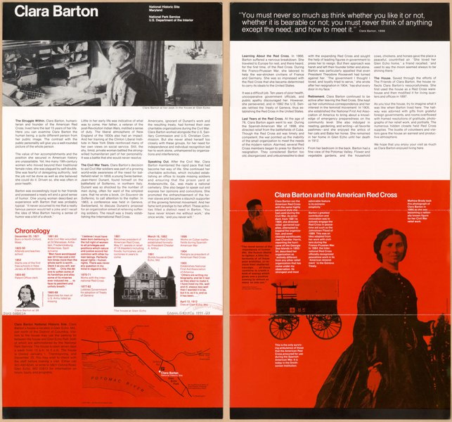
English: Location map showing approach routes to the site in Glen Echo, Montgomery County, Md.; not a map of the site grounds. "*GPO: 1991--281-954/20140 Reprint 1991." Title from panel. Includes text, chronology, and ill. Text, quotation, and ill. on verso. Available also through the Library of Congress Web site as a raster image. |
||
| Title | Clara Barton National Historic Site, Maryland | ||
| Shelf ID | G3844.G42:2C6 1991 .U3 | ||
| Date | |||
| Source | https://www.loc.gov/item/2012585024/ | ||
| Author | United States. National Park Service | ||
| Permission (Reusing this file) |
|
||
| Other versions |
|
||
| Location | Clara Barton National Historic Site · United States · Glen Echo Region. · Maryland · Glen Echo Region · Glen Echo | ||
| Part of | American Memory · Cities And Towns · Catalog · Transportation And Communication · Geography And Map Division | ||
| Subject | United States · Clara Barton National Historic Site · Clara Barton National Historic Site (Md.) · Maps · Tourist Maps · Roads · Maryland · Glen Echo Region · Glen Echo |


Licensing edit
| This image or media file contains material based on a work of a National Park Service employee, created as part of that person's official duties. As a work of the U.S. federal government, such work is in the public domain in the United States. See the NPS website and NPS copyright policy for more information. |
File history
Click on a date/time to view the file as it appeared at that time.
| Date/Time | Thumbnail | Dimensions | User | Comment | |
|---|---|---|---|---|---|
| current | 16:55, 21 May 2018 |  | 5,064 × 4,724 (68.44 MB) | Fæ (talk | contribs) | LOC Maps https://www.loc.gov/item/2012585024/ #12952 |
You cannot overwrite this file.
File usage on Commons
The following page uses this file: