File:Clima de Chile fr.png
Clima_de_Chile_fr.png (384 × 404 pixels, file size: 96 KB, MIME type: image/png)
Captions
Captions

|
This meteorology image could be re-created using vector graphics as an SVG file. This has several advantages; see Commons:Media for cleanup for more information. If an SVG form of this image is available, please upload it and afterwards replace this template with
{{vector version available|new image name}}.
It is recommended to name the SVG file “Clima de Chile fr.svg”—then the template Vector version available (or Vva) does not need the new image name parameter. |
Summary edit
| DescriptionClima de Chile fr.png |
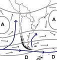
English: Weather maps showing the usual position of weather system around the southern part of South America .
Français : Carte de surface montrant les systèmes météorologiques affectant habituellement le sud de l'Amérique du Sud |
| Date | 12 July 2010, 18:43 (UTC) |
| Source | |
| Author |
|
| This is a retouched picture, which means that it has been digitally altered from its original version. The original can be viewed here: Clima de Chile.JPG:
|
| Public domainPublic domainfalsefalse |
| |
This work has been released into the public domain by its author, Example, at the [[::|English Wikipedia]] project. This applies worldwide. In case this is not legally possible: |
Original upload log edit
This image is a derivative work of the following images:
- File:Clima de Chile.JPG licensed with PD-user-w
- 2010-07-12T18:33:57Z Pierre cb 384x404 (30838 Bytes) {{Information |Description= Weather maps showing the usual position of weather system around the southern part of South America. |Source= {{Own}} |Date= 2008-02-08 |Author=[[:en:UserDentren|Dentren]] |Permission= {{PD-user-w|
Uploaded with derivativeFX
File history
Click on a date/time to view the file as it appeared at that time.
| Date/Time | Thumbnail | Dimensions | User | Comment | |
|---|---|---|---|---|---|
| current | 18:18, 2 June 2020 |  | 384 × 404 (96 KB) | Maulucioni (talk | contribs) | Perou |
| 18:45, 12 July 2010 |  | 384 × 404 (80 KB) | Pierre cb (talk | contribs) | {{Information |Description={{en|1=Weather maps showing the usual position of weather system around the southern part of South America}}. {{fr|1=Carte de surface montrant les systèmes météorologiques affectant habituellement le sud de l'Amérique du Sud |
You cannot overwrite this file.
File usage on Commons
There are no pages that use this file.
File usage on other wikis
The following other wikis use this file:
- Usage on ast.wikipedia.org
- Usage on es.wikipedia.org
- Clima de Argentina
- Brazo del Sudoeste
- Usuario:Jorval/Brazo del Sudoeste (corregido)
- Usuario:Jorval/Sección Clima y vientos
- Usuario:Jorval/Canal Beagle sector Isla Gordon-Canal Murray
- Usuario:Jorval/Colocar secciones Clima y vientos - Flora y fauna en artículos canales patagónicos y otros
- Canal Beagle parte central
- Canal Beagle parte oriental
- Usuario:Jorval/Costa exterior al sur del canal Beagle
- Costa exterior al sur del canal Beagle
- Anticiclón del Pacífico Sur
- Usage on fr.wikipedia.org
- Usage on hy.wikipedia.org
- Usage on pt.wikipedia.org
Metadata
This file contains additional information such as Exif metadata which may have been added by the digital camera, scanner, or software program used to create or digitize it. If the file has been modified from its original state, some details such as the timestamp may not fully reflect those of the original file. The timestamp is only as accurate as the clock in the camera, and it may be completely wrong.
| Horizontal resolution | 37.8 dpc |
|---|---|
| Vertical resolution | 37.8 dpc |
