File:Climograma Santiago.png
No higher resolution available.
Climograma_Santiago.png (450 × 450 pixels, file size: 11 KB, MIME type: image/png)
Captions
Captions
Add a one-line explanation of what this file represents
Summary edit
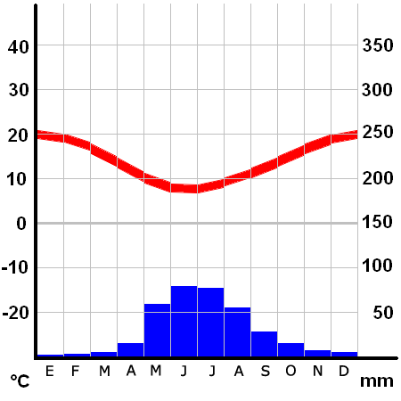
Climograma de Santiago de Chile (Pudahuel)
- Ubicación: 33º23' S 70º47' W
- Altura: 475 msnm
Licensing edit
Climograma basado en el realizado por Klimadiagramm archive copy at the Wayback Machine creado por Homeruniverse, cuyos archivos pertenecen al dominio público
Note: This tag is deprecated, please replace this template with {{PD-user-w}}
| |
This work has been released into the public domain by its author, Homeruniverse, at the German Wikipedia project. This applies worldwide. In case this is not legally possible: |
| Annotations | This image is annotated: View the annotations at Commons |
File history
Click on a date/time to view the file as it appeared at that time.
| Date/Time | Thumbnail | Dimensions | User | Comment | |
|---|---|---|---|---|---|
| current | 04:26, 26 January 2006 | | 450 × 450 (11 KB) | B1mbo (talk | contribs) | Santiago Category:Santiago de Chile Climograma de Santiago de Chile (Pudahuel) *Ubicación: 33º23' S 70º47' W *Altura: 475 msnm ==Licensing== Climograma basado en el realizado por [http://homeruniverse.n� |
You cannot overwrite this file.
File usage on Commons
The following page uses this file:
File usage on other wikis
The following other wikis use this file:
- Usage on ca.wikipedia.org
- Usage on crh.wikipedia.org
- Usage on diq.wikipedia.org
- Usage on es.wikipedia.org
- Usage on es.wikivoyage.org
- Usage on fi.wikipedia.org
- Usage on fr.wikipedia.org
- Usage on gl.wikipedia.org
- Usage on hu.wikipedia.org
- Usage on id.wikipedia.org
- Usage on ja.wikibooks.org
- Usage on pl.wikipedia.org
- Usage on pt.wikipedia.org
- Usage on sq.wikipedia.org
- Usage on zh-classical.wikipedia.org
- Usage on zh.wikipedia.org