File:Close-up view of portal joint pin-connection with star plate, and typical riveted girders and latticed posts. (Nov. 25, 1988) - University Heights Bridge, Spanning Harlem River HAER NY,31-NEYO,178-15.tif

Size of this JPG preview of this TIF file: 486 × 600 pixels. Other resolutions: 194 × 240 pixels | 389 × 480 pixels | 622 × 768 pixels | 830 × 1,024 pixels | 1,659 × 2,048 pixels | 4,051 × 5,000 pixels.
Original file (4,051 × 5,000 pixels, file size: 19.32 MB, MIME type: image/tiff)
Captions
Captions
Add a one-line explanation of what this file represents
Summary edit
| Close-up view of portal joint pin-connection with star plate, and typical riveted girders and latticed posts. (Nov. 25, 1988) - University Heights Bridge, Spanning Harlem River at 207th Street and West Harlem Road, New York, New York County, NY | ||||
|---|---|---|---|---|
| Photographer |
Neumann, Peter |
|||
| Title |
Close-up view of portal joint pin-connection with star plate, and typical riveted girders and latticed posts. (Nov. 25, 1988) - University Heights Bridge, Spanning Harlem River at 207th Street and West Harlem Road, New York, New York County, NY |
|||
| Depicted place | New York; New York County; New York | |||
| Date | 1988 | |||
| Dimensions | 4 x 5 in. | |||
| Current location |
Library of Congress Prints and Photographs Division Washington, D.C. 20540 USA http://hdl.loc.gov/loc.pnp/pp.print |
|||
| Accession number |
HAER NY,31-NEYO,178-15 |
|||
| Credit line |
|
|||
| Notes |
|
|||
| Source | https://www.loc.gov/pictures/item/ny1596.photos.349932p | |||
| Permission (Reusing this file) |
|
|||

| Object location | | View this and other nearby images on: OpenStreetMap |
|---|
File history
Click on a date/time to view the file as it appeared at that time.
| Date/Time | Thumbnail | Dimensions | User | Comment | |
|---|---|---|---|---|---|
| current | 19:38, 29 July 2014 | 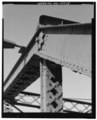 | 4,051 × 5,000 (19.32 MB) | Fæ (talk | contribs) | GWToolset: Creating mediafile for Fæ. HABS 24 July 2014 (2301:2600) |
You cannot overwrite this file.
File usage on Commons
The following page uses this file: