File:Cologne area growth red colours.svg

Size of this PNG preview of this SVG file: 600 × 600 pixels. Other resolutions: 240 × 240 pixels | 480 × 480 pixels | 768 × 768 pixels | 1,024 × 1,024 pixels | 2,048 × 2,048 pixels | 1,112 × 1,112 pixels.
Original file (SVG file, nominally 1,112 × 1,112 pixels, file size: 1.18 MB)
Captions
Captions
Add a one-line explanation of what this file represents
Summary edit
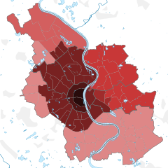
| Description |
Deutsch: Entwicklung des Stadtgebiets von Köln, 1180 bis 1975.
English: Growth of municipal area of Cologne, 1180 until 1975.
Legend: vor/before 1794: 40,10 km2
bis/until 1888: 100,60 km2
1888: 113,33 km2
1910: 117,41 km2
1914: 197,26 km2
1922: 251,25 km2
1975: 405,16 km2 |
| Date | |
| Source |
Stadt Köln, page 8 - colour infills have been adjusted to current district boundaries. Map based on File:Cologne subdivisions blank grey.svg by TUBS |
| Author | Own work |
| Other versions |
|

Licensing edit
This file is licensed under the Creative Commons Attribution-Share Alike 2.0 Generic license.
- You are free:
- to share – to copy, distribute and transmit the work
- to remix – to adapt the work
- Under the following conditions:
- attribution – You must give appropriate credit, provide a link to the license, and indicate if changes were made. You may do so in any reasonable manner, but not in any way that suggests the licensor endorses you or your use.
- share alike – If you remix, transform, or build upon the material, you must distribute your contributions under the same or compatible license as the original.
File history
Click on a date/time to view the file as it appeared at that time.
| Date/Time | Thumbnail | Dimensions | User | Comment | |
|---|---|---|---|---|---|
| current | 22:08, 19 December 2010 | | 1,112 × 1,112 (1.18 MB) | ZH2010 (talk | contribs) | {{Information |Description={{de|Entwicklung des Stadtgebiets von Köln.}} {{en|Growth of municipal area of Cologne.}} |Source=[http://www.stadt-koeln.de/mediaasset/content/pdf15/pegel_k__ln__millionenstadt_2010.pdf Stadt Kö |
You cannot overwrite this file.
File usage on Commons
The following page uses this file: