File:Colonisation 2007.png

Original file (1,425 × 625 pixels, file size: 44 KB, MIME type: image/png)
Captions
Captions
| Description |
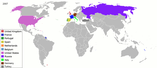
Map of major world powers by year, derived from public domain animated map on wikipedia.
As the orriginal licence of the animation was Public Domain, this image which has been derived from it is too:
|
||||||||||||||||||
| Date | |||||||||||||||||||
| Source | public domain animated map by ArdadN here | ||||||||||||||||||
| Author | ArdadN | ||||||||||||||||||
.jpg)
._LOC_2001620596.jpg)

|
This historical map image could be re-created using vector graphics as an SVG file. This has several advantages; see Commons:Media for cleanup for more information. If an SVG form of this image is available, please upload it and afterwards replace this template with
{{vector version available|new image name}}.
It is recommended to name the SVG file “Colonisation 2007.svg”—then the template Vector version available (or Vva) does not need the new image name parameter. |
File history
Click on a date/time to view the file as it appeared at that time.
| Date/Time | Thumbnail | Dimensions | User | Comment | |
|---|---|---|---|---|---|
| current | 22:06, 28 February 2019 | | 1,425 × 625 (44 KB) | Nioktest (talk | contribs) | Coloration en bleu de Mayotte et de La Réunion, départements de l'état français. |
| 01:51, 22 May 2010 |  | 1,425 × 625 (75 KB) | Kieran4 (talk | contribs) | Add Aruba and Curacao | |
| 17:31, 3 May 2008 |  | 1,425 × 625 (56 KB) | SelfQ~commonswiki (talk | contribs) | {{Information |Description= |Source= |Date= |Author= |Permission= |other_versions= }} | |
| 10:41, 22 March 2007 |  | 1,425 × 625 (65 KB) | Roke~commonswiki (talk | contribs) | {{Information |Description=Map of major world powers by year, derived from public domain animated map on wikipedia. {{Maps of world history}} As the orriginal licence of the animation was Public Domain, this image which has been derived from it is too: { |
You cannot overwrite this file.
File usage on Commons
The following 2 pages use this file:
File usage on other wikis
The following other wikis use this file:
- Usage on en.wikipedia.org
- Usage on fr.wikipedia.org
- Usage on oc.wikipedia.org
- Usage on vi.wikipedia.org