File:Congo-Uganda border.jpg

Size of this preview: 800 × 600 pixels. Other resolutions: 320 × 240 pixels | 640 × 480 pixels | 1,024 × 768 pixels | 1,280 × 960 pixels.
Original file (1,280 × 960 pixels, file size: 319 KB, MIME type: image/jpeg)
Captions
Captions
Add a one-line explanation of what this file represents
Summary edit
| Description |
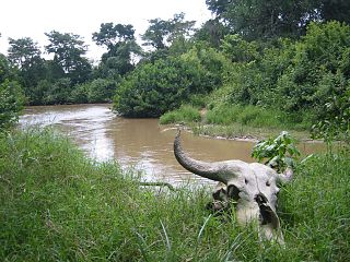
Congo begins on the far bank; it is one of the least-governed areas on the planet, representing a kind of hole in the world's governance. Usable with attribution and link to: futureatlas.com/blog/. |
| Date | |
| Source | The Congo-Uganda border |
| Author | futureatlas.com |
| Camera location | | View this and other nearby images on: OpenStreetMap |
|---|
Licensing edit
This file is licensed under the Creative Commons Attribution 2.0 Generic license.
- You are free:
- to share – to copy, distribute and transmit the work
- to remix – to adapt the work
- Under the following conditions:
- attribution – You must give appropriate credit, provide a link to the license, and indicate if changes were made. You may do so in any reasonable manner, but not in any way that suggests the licensor endorses you or your use.
| This image was originally posted to Flickr by futureatlas.com at https://www.flickr.com/photos/87913776@N00/394857682. It was reviewed on 19 April 2013 by FlickreviewR and was confirmed to be licensed under the terms of the cc-by-2.0. |
File history
Click on a date/time to view the file as it appeared at that time.
| Date/Time | Thumbnail | Dimensions | User | Comment | |
|---|---|---|---|---|---|
| current | 05:19, 19 April 2013 | | 1,280 × 960 (319 KB) | Ji-Elle (talk | contribs) | {{Information |Description=Congo begins on the far bank; it is one of the least-governed areas on the planet, representing a kind of hole in the [http://www.futureatlas.com/Issues/Govt_reach.htm world's governance]. Usable with attribution and link t... |
You cannot overwrite this file.
File usage on Commons
There are no pages that use this file.
File usage on other wikis
The following other wikis use this file:
- Usage on de.wikipedia.org
- Usage on en.wikipedia.org
- Usage on es.wikipedia.org
- Usage on fr.wikipedia.org
- Usage on it.wikipedia.org
- Usage on sv.wikipedia.org