File:Consol9map.png

Size of this preview: 800 × 445 pixels. Other resolutions: 320 × 178 pixels | 640 × 356 pixels | 1,238 × 688 pixels.
Original file (1,238 × 688 pixels, file size: 494 KB, MIME type: image/png)
Captions
Captions
Add a one-line explanation of what this file represents
Summary edit
| Description |
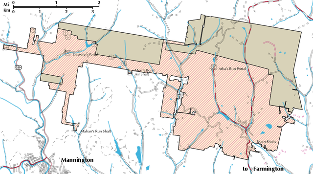
English: Map of Consol No. 9 coal mine, site of the Farmington Mine disaster in relation to surface roads and streams. At the time of the disaster, the pink area was developed as a room and pillar mine, while retreat mining had been completed in the brown area. Highway names, town names and map scale added June 24, 2009 by the uploader, who extends no copyright claims over these additions. |
| Date | |
| Source | Adapted from: Final Phase II Technical Report, THERMOACOUSTIC LIQUEFACTION OF COAL MINE METHANE TO PRODUCE LNG FOR HEAVY VEHICLE APPLICATIONS, U. S. Department of Energy, Page 19, [1] |
| Author | Kashi Aminian, Lloyd English, Douglas Patchen, Hema Siriwardane, West Virginia University National Research Center for Coal and Energy, and Charles D. Estes, Raymond L. Zahradnik, Appalacian-Pacific Coal Mine Methanr Power Company, LLC |
| Camera location | | View this and other nearby images on: OpenStreetMap |
|---|
Licensing edit
This work is in the public domain in the United States because it is a work prepared by an officer or employee of the United States Government as part of that person’s official duties under the terms of Title 17, Chapter 1, Section 105 of the US Code.
Note: This only applies to original works of the Federal Government and not to the work of any individual U.S. state, territory, commonwealth, county, municipality, or any other subdivision. This template also does not apply to postage stamp designs published by the United States Postal Service since 1978. (See § 313.6(C)(1) of Compendium of U.S. Copyright Office Practices). It also does not apply to certain US coins; see The US Mint Terms of Use.
|
 | |
| This file has been identified as being free of known restrictions under copyright law, including all related and neighboring rights. | ||
File history
Click on a date/time to view the file as it appeared at that time.
| Date/Time | Thumbnail | Dimensions | User | Comment | |
|---|---|---|---|---|---|
| current | 19:37, 24 June 2009 | | 1,238 × 688 (494 KB) | Douglas W. Jones (talk | contribs) | {{Information |Description={{en|1=Map of Consol No. 9 coal mine, site of the Farmington Mine disaster in relation to surface roads and streams. Highway names, Town names and map scale added June 24, 2009 by uploader, who extends no copyright claims o |
You cannot overwrite this file.
File usage on Commons
The following page uses this file:
File usage on other wikis
The following other wikis use this file:
- Usage on en.wikipedia.org
- Usage on pt.wikipedia.org