File:Constantinople area map-es.svg

Size of this PNG preview of this SVG file: 800 × 472 pixels. Other resolutions: 320 × 189 pixels | 640 × 378 pixels | 1,024 × 605 pixels | 1,280 × 756 pixels | 2,560 × 1,512 pixels | 818 × 483 pixels.
Original file (SVG file, nominally 818 × 483 pixels, file size: 9.12 MB)
Captions
Captions
Add a one-line explanation of what this file represents
Summary edit
| Description |
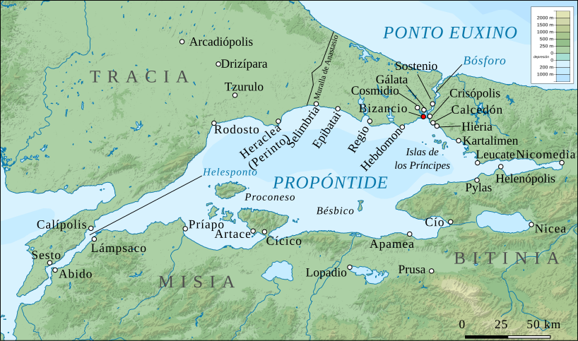
English: Map of Constantinople (modern Istanbul) and its environs during Byzantine times. Base map: Sea of Marmara map.png, slightly edited. Locations and names of settlements taken from: C. Mango & G. Dagron (eds.), Constantinople and its Hinterland, Variorum 1995, pp. xii-xiii, 110-111, 208 |
| Source |
This file was derived from: |
| Author | User:Stegop,User:rowanwindwhistler |
Licensing edit
I, the copyright holder of this work, hereby publish it under the following license:
This file is licensed under the Creative Commons Attribution-Share Alike 3.0 Unported license.
- You are free:
- to share – to copy, distribute and transmit the work
- to remix – to adapt the work
- Under the following conditions:
- attribution – You must give appropriate credit, provide a link to the license, and indicate if changes were made. You may do so in any reasonable manner, but not in any way that suggests the licensor endorses you or your use.
- share alike – If you remix, transform, or build upon the material, you must distribute your contributions under the same or compatible license as the original.
File history
Click on a date/time to view the file as it appeared at that time.
| Date/Time | Thumbnail | Dimensions | User | Comment | |
|---|---|---|---|---|---|
| current | 11:25, 17 July 2019 | | 818 × 483 (9.12 MB) | Rowanwindwhistler (talk | contribs) | Uploading a file from a free published source using File Upload Wizard |
You cannot overwrite this file.
File usage on Commons
The following 5 pages use this file:
.svg)
File usage on other wikis
The following other wikis use this file:
- Usage on es.wikipedia.org