File:Converted railway station- Lee on Solent (geograph 2824684).jpg
No higher resolution available.
Converted_railway_station-_Lee_on_Solent_(geograph_2824684).jpg (640 × 482 pixels, file size: 64 KB, MIME type: image/jpeg)
Captions
Captions
Add a one-line explanation of what this file represents
Summary edit
.jpg&action=edit§ion=1)
| Description |
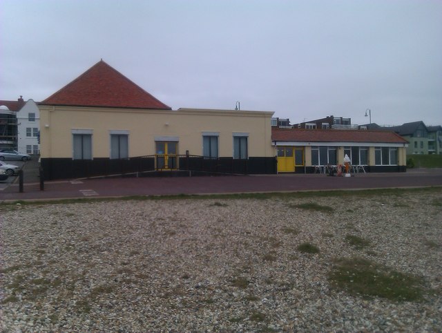
English: Converted railway station: Lee on Solent Unlikely though it may seem, the amusement arcade comprising the left section of the building in this view was originally part of the terminus station of the Lee on Solent branch line, with the platforms and tracks stretching along the seafront to the right. The track was removed in 1939. |
| Date | |
| Source | From geograph.org.uk |
| Author | David Martin |
| Permission (Reusing this file) |
Creative Commons Attribution Share-alike license 2.0 |
| Attribution (required by the license) | David Martin / Converted railway station: Lee on Solent / |
| Camera location | | View this and other nearby images on: OpenStreetMap |
|---|
.jpg¶ms=050.800892_N_-001.203735_E_globe:Earth_type:camera_source:geograph-osgb36(SU56210045)_heading:90.00&language=en)
| Object location | | View this and other nearby images on: OpenStreetMap |
|---|
.jpg¶ms=050.800890_N_-001.203590_E_globe:Earth_class:object_type:object_source:geograph-osgb36(SU56220045)_heading:90.00&language=en)
Licensing edit
.jpg&action=edit§ion=2)

|
This image was taken from the Geograph project collection. See this photograph's page on the Geograph website for the photographer's contact details. The copyright on this image is owned by David Martin and is licensed for reuse under the Creative Commons Attribution-ShareAlike 2.0 license.
|
This file is licensed under the Creative Commons Attribution-Share Alike 2.0 Generic license.
Attribution: David Martin
- You are free:
- to share – to copy, distribute and transmit the work
- to remix – to adapt the work
- Under the following conditions:
- attribution – You must give appropriate credit, provide a link to the license, and indicate if changes were made. You may do so in any reasonable manner, but not in any way that suggests the licensor endorses you or your use.
- share alike – If you remix, transform, or build upon the material, you must distribute your contributions under the same or compatible license as the original.
File history
Click on a date/time to view the file as it appeared at that time.
| Date/Time | Thumbnail | Dimensions | User | Comment | |
|---|---|---|---|---|---|
| current | 14:33, 1 November 2020 | | 640 × 482 (64 KB) | Lamberhurst (talk | contribs) | Transferred from geograph.co.uk using [https://tools.wmflabs.org/geograph2commons/ geograph2commons] |
You cannot overwrite this file.
File usage on Commons
The following page uses this file:
.jpg&oldid=867991617)