File:Cook Islands Map.png
No higher resolution available.
Cook_Islands_Map.png (330 × 355 pixels, file size: 5 KB, MIME type: image/png)
Captions
Captions
Add a one-line explanation of what this file represents
Summary edit
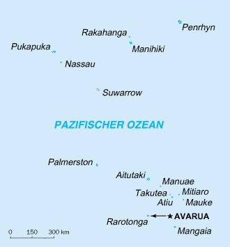
| Description | Geographical map of the cook islands |
| Date | |
| Source | CIA world factbook |
| Author | CIA |
Licensing edit
This image is in the public domain because it contains materials that originally came from the United States Central Intelligence Agency's World Factbook.
|
 |
File history
Click on a date/time to view the file as it appeared at that time.
| Date/Time | Thumbnail | Dimensions | User | Comment | |
|---|---|---|---|---|---|
| current | 14:49, 23 October 2013 | | 330 × 355 (5 KB) | Ras67 (talk | contribs) | frame removed |
| 12:04, 8 July 2006 |  | 330 × 355 (5 KB) | Eptalon (talk | contribs) | {{Information |Description=Geographical map of the cook islands |Source=CIA wortld factbook |Date=20060708 |Author=CIA |Permission= |other_versions= }} |
You cannot overwrite this file.
File usage on Commons
There are no pages that use this file.
File usage on other wikis
The following other wikis use this file:
- Usage on als.wikipedia.org
- Usage on de.wikipedia.org
- Usage on de.wikivoyage.org
- Usage on dsb.wikipedia.org
- Usage on he.wikipedia.org