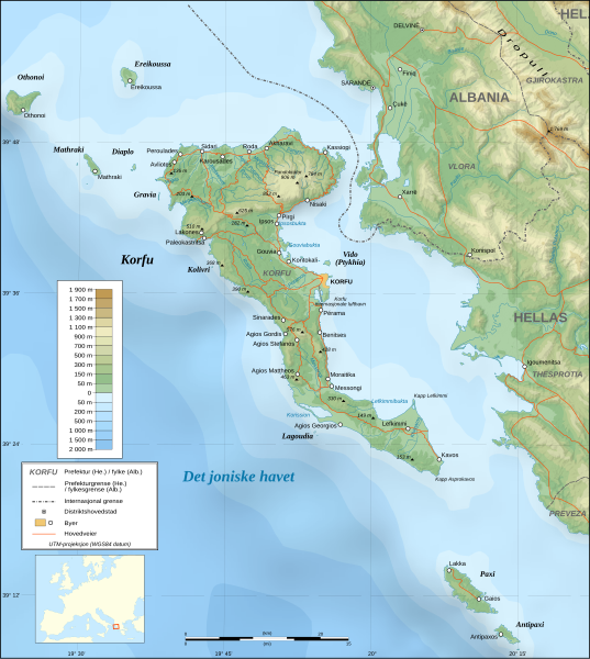
File:Corfu topographic map-nb.svg

Size of this PNG preview of this SVG file: 537 × 600 pixels. Other resolutions: 215 × 240 pixels | 430 × 480 pixels | 688 × 768 pixels | 917 × 1,024 pixels | 1,834 × 2,048 pixels | 2,100 × 2,345 pixels.
Original file (SVG file, nominally 2,100 × 2,345 pixels, file size: 2.46 MB)
Captions
Captions
Add a one-line explanation of what this file represents
Summary edit
| Description | |
| Date | |
| Source | Image:Corfu topographic map-en.svg |
| Author | Eric Gaba (translated by Jon Harald Søby) |
| Permission (Reusing this file) |
GFDL & CC-by-SA |
| Other versions |
[]
|
| SVG development |


Licensing edit
I, the copyright holder of this work, hereby publish it under the following licenses:

|
Permission is granted to copy, distribute and/or modify this document under the terms of the GNU Free Documentation License, Version 1.2 or any later version published by the Free Software Foundation; with no Invariant Sections, no Front-Cover Texts, and no Back-Cover Texts. A copy of the license is included in the section entitled GNU Free Documentation License. |
| This file is licensed under the Creative Commons Attribution-Share Alike 3.0 Unported license. | ||
| ||
| This licensing tag was added to this file as part of the GFDL licensing update. |
This file is licensed under the Creative Commons Attribution-Share Alike 2.5 Generic, 2.0 Generic and 1.0 Generic license.
- You are free:
- to share – to copy, distribute and transmit the work
- to remix – to adapt the work
- Under the following conditions:
- attribution – You must give appropriate credit, provide a link to the license, and indicate if changes were made. You may do so in any reasonable manner, but not in any way that suggests the licensor endorses you or your use.
- share alike – If you remix, transform, or build upon the material, you must distribute your contributions under the same or compatible license as the original.
You may select the license of your choice.
File history
Click on a date/time to view the file as it appeared at that time.
| Date/Time | Thumbnail | Dimensions | User | Comment | |
|---|---|---|---|---|---|
| current | 13:13, 5 September 2008 | | 2,100 × 2,345 (2.46 MB) | Sting (talk | contribs) | Bug in the full view display |
| 13:01, 5 September 2008 |  | 2,100 × 2,345 (2.46 MB) | Sting (talk | contribs) | Using bathymetry from ETOPO1 ; new standard colors | |
| 13:00, 20 December 2007 |  | 2,100 × 2,345 (3.16 MB) | Jon Harald Søby (talk | contribs) | fixing placement issues | |
| 12:52, 20 December 2007 |  | 2,100 × 2,345 (3.16 MB) | Jon Harald Søby (talk | contribs) | {{Information |Description={{en|Topographic map in Norwegian (Bokmål) of the Corfu island area in Greece.}} {{nb|Topografisk kart over Korfu i Hellas, på bokmål.}} |Source=[[:Image:Corfu top |
You cannot overwrite this file.
File usage on Commons
The following 14 pages use this file:
- File:Corfu topographic map-Stad.PNG
- File:Corfu topographic map-be.svg
- File:Corfu topographic map-blank.svg
- File:Corfu topographic map-de.svg
- File:Corfu topographic map-el.svg
- File:Corfu topographic map-en.svg
- File:Corfu topographic map-en librsvg.png
- File:Corfu topographic map-en rendersvg.png
- File:Corfu topographic map-es.svg
- File:Corfu topographic map-fr.svg
- File:Corfu topographic map-hu.svg
- File:Corfu topographic map-mk.svg
- File:Corfu topographic map-nb.svg
- Template:Other versions/Corfu topographic map
File usage on other wikis
The following other wikis use this file:
- Usage on uk.wikipedia.org