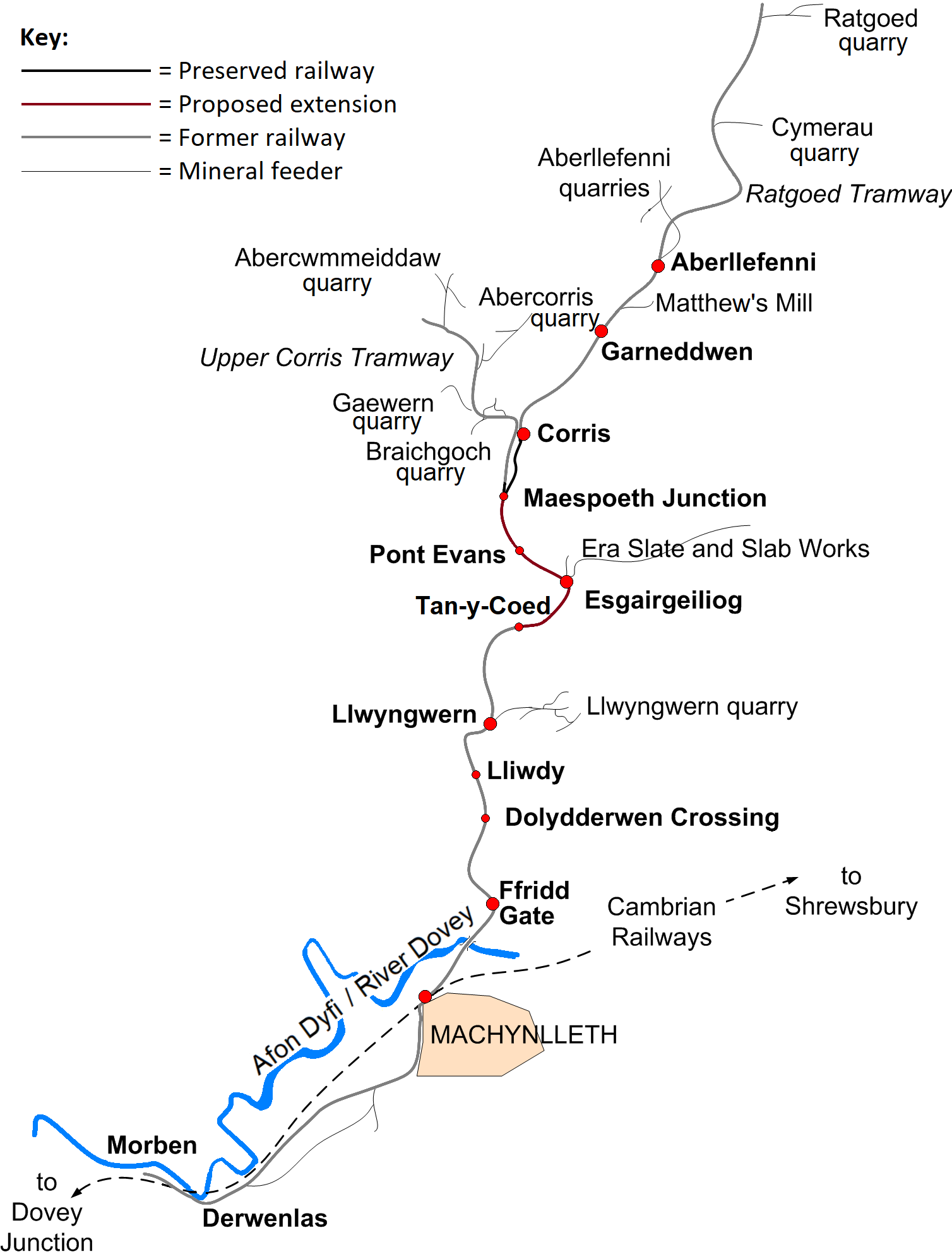
File:CorrisRailwayMap.png
Size of this preview: 453 × 599 pixels. Other resolutions: 181 × 240 pixels | 363 × 480 pixels | 581 × 768 pixels | 774 × 1,024 pixels | 1,508 × 1,994 pixels.
Original file (1,508 × 1,994 pixels, file size: 229 KB, MIME type: image/png)
Captions
Captions
Add a one-line explanation of what this file represents
Summary edit
| Description | |
| Date | 15 September 2006 (original upload date) |
| Source | No machine-readable source provided. Own work assumed (based on copyright claims). |
| Author | No machine-readable author provided. Dan Crow assumed (based on copyright claims). |
Licensing edit
I, the copyright holder of this work, hereby publish it under the following license:

|
Permission is granted to copy, distribute and/or modify this document under the terms of the GNU Free Documentation License, Version 1.2 or any later version published by the Free Software Foundation; with no Invariant Sections, no Front-Cover Texts, and no Back-Cover Texts. A copy of the license is included in the section entitled GNU Free Documentation License. |
| This file is licensed under the Creative Commons Attribution-Share Alike 3.0 Unported license. | ||
| ||
| This licensing tag was added to this file as part of the GFDL licensing update. |
File history
Click on a date/time to view the file as it appeared at that time.
| Date/Time | Thumbnail | Dimensions | User | Comment | |
|---|---|---|---|---|---|
| current | 17:37, 8 December 2020 | | 1,508 × 1,994 (229 KB) | WT79 (talk | contribs) | transparentify background; better colour filling for railway; better station shapes |
| 19:37, 7 December 2020 |  | 1,508 × 1,994 (231 KB) | WT79 (talk | contribs) | small icon for Maes-poeth, as it ''was'' an unofficial stopping place; colour railway line according to preservation status (and add key) | |
| 14:58, 26 June 2020 |  | 1,508 × 1,994 (221 KB) | WT79 (talk | contribs) | added River Dovey | |
| 17:12, 25 June 2020 |  | 1,508 × 1,994 (183 KB) | WT79 (talk | contribs) | Smaller icons for Pont Evans, Lliwdy, and Dolydderwen Crossing, as they were not official stopping places. Added 'quarry' after quarries. apostrophe in "Matthew's Mill". | |
| 14:19, 19 September 2006 |  | 1,508 × 1,994 (161 KB) | Gwernol (talk | contribs) | Map of the Corris Railway Author: Dan Crow | |
| 20:55, 16 September 2006 |  | 1,480 × 1,989 (157 KB) | Gwernol (talk | contribs) | Map of the Corris Railway Author: Dan Crow | |
| 13:47, 15 September 2006 |  | 1,496 × 1,989 (140 KB) | Gwernol (talk | contribs) | {(Information |Description=Map of the Corris Railway |Date=15 September 2006 |Author=Dan Crow}} | |
| 13:28, 15 September 2006 |  | 1,442 × 1,978 (136 KB) | Gwernol (talk | contribs) | {{Information |Description=Map of the Corris Railway |Date=15 September 2006 |Author=Dan Crow }} | |
| 13:02, 15 September 2006 |  | 1,324 × 1,937 (102 KB) | Gwernol (talk | contribs) | Map of the Corris Railway Author: Dan Crow |
You cannot overwrite this file.
File usage on Commons
The following 4 pages use this file:
File usage on other wikis
The following other wikis use this file:
- Usage on cy.wikipedia.org
- Usage on de.wikipedia.org
- Usage on en.wikipedia.org
- Usage on kw.wikipedia.org
- Usage on www.wikidata.org