File:Corsica (Landsat 7).png

Size of this preview: 370 × 600 pixels. Other resolutions: 148 × 240 pixels | 296 × 480 pixels | 474 × 768 pixels | 631 × 1,024 pixels | 1,263 × 2,048 pixels | 2,689 × 4,359 pixels.
Original file (2,689 × 4,359 pixels, file size: 15.96 MB, MIME type: image/png)
Captions
Captions
Add a one-line explanation of what this file represents
Summary
edit.png&action=edit§ion=1)
Note: this image was scaled down to allow thumbnail generation, and brightness was slightly increased to enhance display on a computer screen. For the high-definition version, see File:Corsica (Landsat 7) - high definition.png.
_-_high_definition.png)
| Description |
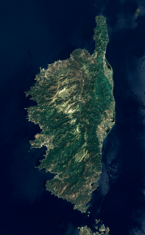
English: View of Corsica from the Landsat 7 satellite. This picture was built using data from the ETM+ instrument, by merging two datasets covering each half of the island. Bands 1, 2 and 3 (respectively blue, green and red) were combined to get a true-color image. Data from band 8 (panchromatic, visible + near infrared) was used as intensity value. Colors were then enhanced using an image manipulation program. Bands 1, 2 and 3 have a resolution of 30 m, and band 8 has a resolution of 15 m. Data was acquired on 2002-06-17. Most of the mountains thus lack snow, but névés can still be seen on highest peaks.
Français : Vue de la Corse depuis le satellite Landsat 7. Cette image a été obtenue à partir des données de l'instrument ETM+, en fusionnant deux ensembles de données pour couvrir toute la surface de l'île. Les bandes 1, 2 et 3 (correspondant respectivement aux couleurs bleu, vert, et rouge) ont été combinées pour former une image en couleurs réelles. Les données de la bande 8 (capteur panchromatique sensible à la fois aux couleurs visibles et à l'infrarouge proche) ont été utilisées comme valeurs d'intensité. Les couleurs ont ensuite été réajustées dans un logiciel de retouche d'image. La résolution des bandes 1, 2 et 3 (couleurs visibles) est de 30 m, et celle de la bande 8 est de 15 m. Les photos satellite ont été prises le 17 juin 2002. On peut constater l'absence de neige sur la plupart des montagnes corses, sauf quelques névés encore présents sur les plus hauts sommets. |
| Date | |
| Source | Data from USGS EarthExplorer. Links to metadata of individual images: LE71930312002168EDC00 and LE71930302002168EDC00 |
| Author |
|
| Other versions | File:Corsica (Landsat 7) - high definition.png (high-definition version) |
| Object location | | View this and other nearby images on: OpenStreetMap |
|---|
.png¶ms=042.163403_N_0009.129639_E_globe:Earth_class:object_type:object_region:FR_dim:220km_&language=en)
| This file is in the public domain in the United States because it was solely created by NASA. NASA copyright policy states that "NASA material is not protected by copyright unless noted". (See Template:PD-USGov, NASA copyright policy page or JPL Image Use Policy.) | ||
 |
Warnings:
|
This work is based on a work in the public domain. It has been digitally enhanced and/or modified. This derivative work has been (or is hereby) released into the public domain by its author, Telperion. This applies worldwide.
In some countries this may not be legally possible; if so: |
File history
Click on a date/time to view the file as it appeared at that time.
| Date/Time | Thumbnail | Dimensions | User | Comment | |
|---|---|---|---|---|---|
| current | 19:42, 28 September 2011 | | 2,689 × 4,359 (15.96 MB) | Telperion (talk | contribs) | removed bogus color profile |
| 13:22, 25 September 2011 |  | 2,689 × 4,359 (16.02 MB) | Telperion (talk | contribs) | small color correction | |
| 15:24, 24 September 2011 |  | 2,689 × 4,359 (15.81 MB) | Telperion (talk | contribs) | another try | |
| 15:10, 24 September 2011 |  | 2,843 × 4,609 (17.51 MB) | Telperion (talk | contribs) | {{Information |Description ={{en|1=View of Corsica from the Landsat 7 satellite. This picture was built using data from the ETM+ instrument, by merging two datasets covering each half of the island. Bands 1, 2 and 3 (r |
You cannot overwrite this file.
File usage on Commons
The following 6 pages use this file:
File usage on other wikis
The following other wikis use this file:
- Usage on es.wikipedia.org
- Usage on fr.wikipedia.org
- Usage on fr.wikinews.org
- Catégorie:15 mai 2008
- Catégorie:15 mai 2009
- Catégorie:15 mai 2010
- Catégorie:15 mai 2011
- Catégorie:15 mai 2012
- Modèle:Éphéméride-15 mai
- Évènements du 15 mai 2012
- Catégorie:15 mai 2013
- Évènements du 15 mai 2013
- Catégorie:15 mai 2014
- Évènements du 15 mai 2014
- Catégorie:15 mai 2015
- Évènements du 15 mai 2015
- Catégorie:15 mai 2016
- Évènements du 15 mai 2016
- Catégorie:15 mai 2017
- Évènements du 15 mai 2017
- Catégorie:15 mai 2018
- Évènements du 15 mai 2018
- Catégorie:15 mai 2019
- Évènements du 15 mai 2019
- Catégorie:15 mai 2020
- Évènements du 15 mai 2020
- Catégorie:15 mai 2021
- Catégorie:15 mai 2022
- Catégorie:15 mai 2023
- Usage on gcr.wikipedia.org
- Usage on www.wikidata.org
- Usage on zh.wikipedia.org
.png&oldid=868730916)