File:Cours de la rivière d'Hudson et la cõmunication avec le Canada par le Lac Champlain jusqu'au Fort Chambly. NYPL484224.tiff

Size of this JPG preview of this TIF file: 495 × 599 pixels. Other resolutions: 198 × 240 pixels | 397 × 480 pixels | 635 × 768 pixels | 846 × 1,024 pixels | 1,692 × 2,048 pixels | 3,994 × 4,833 pixels.
Original file (3,994 × 4,833 pixels, file size: 55.23 MB, MIME type: image/tiff)
Captions
Captions
Add a one-line explanation of what this file represents
Summary edit
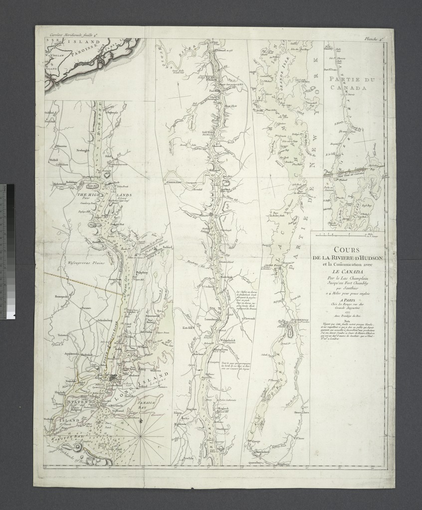
| Description | Cours de la rivière d'Hudson et la cõmunication avec le Canada par le Lac Champlain jusqu'au Fort Chambly.; Lawrence H. Slaughter Collection of English maps, charts, globes, books and atlases / Charts and maps | |||||||||||||||||||||||
| Notes | Inset on sheet 4 of: Caroline méridionale et partie de la Georgie / par le chevr. Bull, gouverneur lieutenant, le Capitaine Gascoign, chevr. Bryan, et De Brahm, arpenteur général de la Caroline méridle. et un des arpenteurs de la Georgie, en 4 feuilles. ''Note 2.'') Depths shown by soundings; relief shown by hachures. ''Note 3.'') Appears in Thomas Jefferys' Atlas ameriquain septentrional. 1778. | |||||||||||||||||||||||
| Item physical description | 1 map : hand col. ; 213 x 20 cm. on sheet 70 x 55 cm. | |||||||||||||||||||||||
| Catalogue call number | Map Div. 97-6174 [LHS 813] | |||||||||||||||||||||||
| Standard reference | Phillips 1212 | |||||||||||||||||||||||
| Date | ||||||||||||||||||||||||
| Source |
http://digitalgallery.nypl.org/nypldigital/dgkeysearchdetail.cfm?imageID=484224
|
|||||||||||||||||||||||
| Author | Sauthier, Claude Joseph -- Cartographer | |||||||||||||||||||||||
| Permission (Reusing this file) |
From The Lionel Pincus and Princess Firyal Map Division. http://maps.nypl.org
|
|||||||||||||||||||||||
| Location | Stephen A. Schwarzman Building / The Lionel Pincus and Princess Firyal Map Division | |||||||||||||||||||||||
| Digital item published | 2-28-2005; updated 3-25-2011 | |||||||||||||||||||||||
| Digital ID | 484224 | |||||||||||||||||||||||

The making of this file was supported by Wikimedia UK.
To see other files made with the support of Wikimedia UK, please see the category Supported by Wikimedia UK.
|
File history
Click on a date/time to view the file as it appeared at that time.
| Date/Time | Thumbnail | Dimensions | User | Comment | |
|---|---|---|---|---|---|
| current | 08:56, 26 April 2014 |  | 3,994 × 4,833 (55.23 MB) | Fæ (talk | contribs) | GWToolset:: Creating mediafile for Fæ. One off charset test Windows-1252 |
You cannot overwrite this file.
File usage on Commons
There are no pages that use this file.