File:Cremona road map.svg

Size of this PNG preview of this SVG file: 679 × 600 pixels. Other resolutions: 272 × 240 pixels | 544 × 480 pixels | 870 × 768 pixels | 1,160 × 1,024 pixels | 2,319 × 2,048 pixels | 718 × 634 pixels.
Original file (SVG file, nominally 718 × 634 pixels, file size: 76 KB)
Captions
Captions
Add a one-line explanation of what this file represents
Summary edit
| Description |
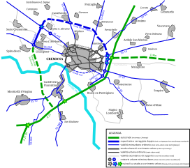
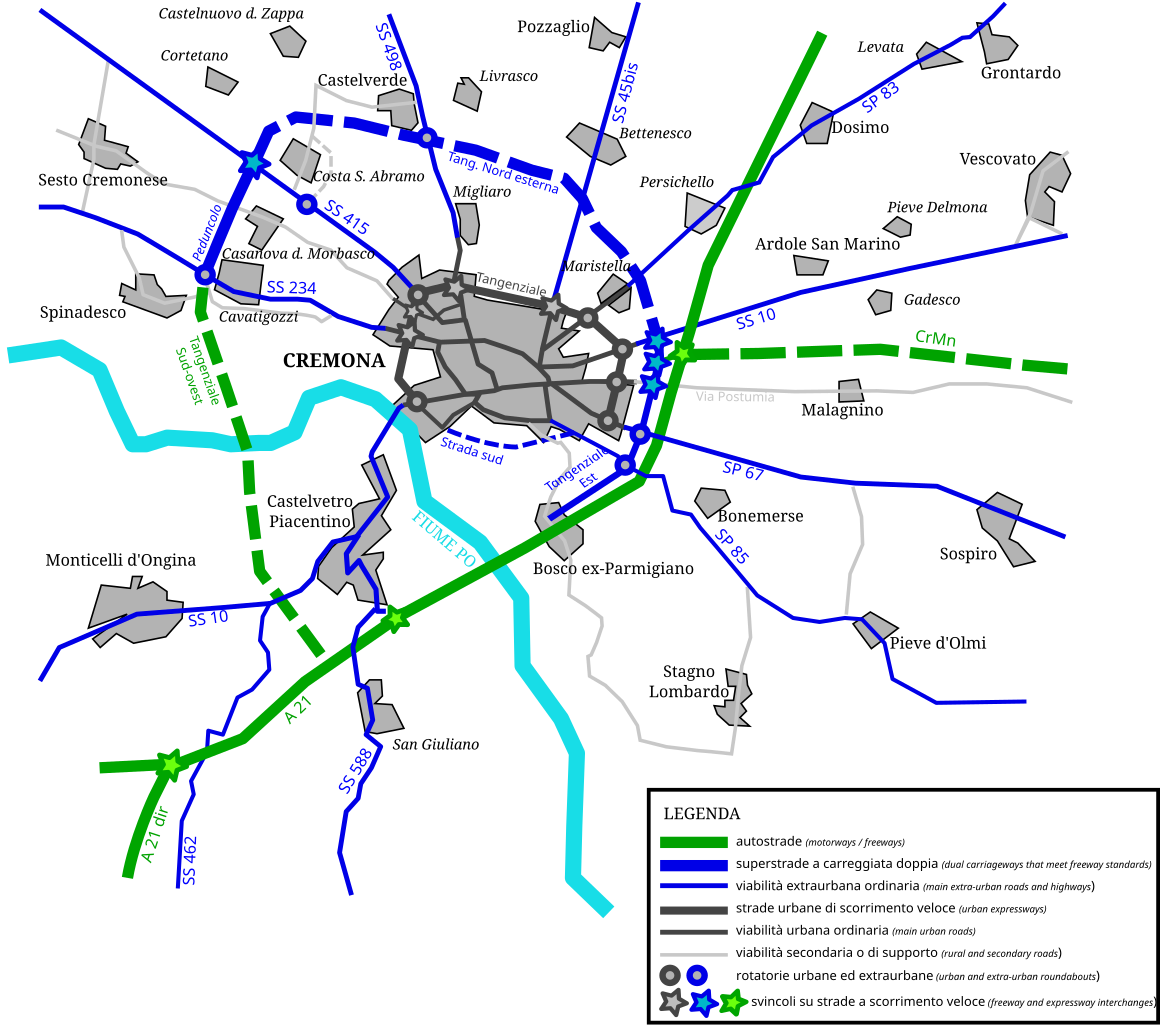
English: Map of roads, expressways and freeways in the city of Cremona and its suburbs. Continuous tracks are road and highways that were completed and open to public traffic before march 15th, 2008; dashed tracks are roads and highways that are currently under construction or just projected. Italiano: Mappa delle principali strade, superstrade ed autostrade dell'area suburbana di Cremona. I tracciati continui sono strade e autostrade completate prima del 15 marzo 2008; i tracciati tratteggiati sono strade e autostrade che sono attualmente in costruzione o solamente allo stadio di progetto. Lombard: Cartìna de le strade e de le autostrade atùrnu a la citàa de Cremuna. Le strade che le era bèle vèrte al 15 de Mars del 2008 i'è segnade cun la linea continua, le strade en custrüsiòon u 'nduma prugetade i'è segnade cun la linea trategiàda. |
| Source | Own work |
| Author | Grasso83 |
Licensing edit
I, the copyright holder of this work, hereby publish it under the following license:
This file is licensed under the Creative Commons Attribution-Share Alike 3.0 Unported license.
- You are free:
- to share – to copy, distribute and transmit the work
- to remix – to adapt the work
- Under the following conditions:
- attribution – You must give appropriate credit, provide a link to the license, and indicate if changes were made. You may do so in any reasonable manner, but not in any way that suggests the licensor endorses you or your use.
- share alike – If you remix, transform, or build upon the material, you must distribute your contributions under the same or compatible license as the original.
File history
Click on a date/time to view the file as it appeared at that time.
| Date/Time | Thumbnail | Dimensions | User | Comment | |
|---|---|---|---|---|---|
| current | 16:39, 1 March 2008 | | 718 × 634 (76 KB) | Grasso83 (talk | contribs) | == Summary == {{Information |Description={{en|Map of roads, expressways and freeways in the city of Cremona and its suburbs. Continuous tracks are road and highways that were completed and open to public traffic before march 15th, 2008; dashed tracks |
| 16:37, 1 March 2008 |  | 718 × 634 (86 KB) | Grasso83 (talk | contribs) | == Summary == {{Information |Description={{en|Map of roads, expressways and freeways in the city of Cremona and its suburbs. Continuous tracks are road and highways that were completed and open to public traffic before march 15th, 2008; dashed tracks | |
| 16:32, 1 March 2008 |  | 744 × 1,052 (76 KB) | Grasso83 (talk | contribs) | {{Information |Description={{en|Map of roads, expressways and freeways in the city of Cremona and its suburbs. Continuous tracks are road and highways that were completed and open to public traffic before march 15th, 2008; dashed tracks are roads and |
You cannot overwrite this file.
File usage on Commons
There are no pages that use this file.
File usage on other wikis
The following other wikis use this file:
- Usage on it.wikipedia.org
- Usage on lmo.wikipedia.org