File:Crisenon cassini.png

Size of this preview: 800 × 426 pixels. Other resolutions: 320 × 170 pixels | 640 × 340 pixels | 1,079 × 574 pixels.
Original file (1,079 × 574 pixels, file size: 1.62 MB, MIME type: image/png)
Captions
Captions
Add a one-line explanation of what this file represents
Summary edit
| Description |
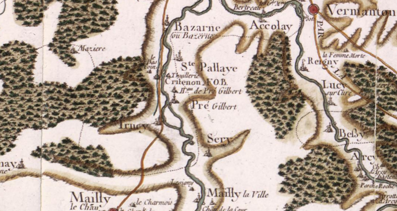
English: Cassini map (18th century), detail, published 1766-1768. Centred on Crisenon and Prégilbert around 20 km south of Auxerre, all in the present Yonne departement, in Burgundy.
The village and the abbey border the Yonne river that flows south-north, cutting through the middle of the map. Its tributary the river Cure flows south-north on the east side of the map (right side) and joins the Yonne at Cravant, just beyond the upper border of the map.
Français : Carte de Cassini (XVIIIe s.), détail, vers le centre du département de l'Yonne, en Bourgogne. Carte centrée sur l'abbaye de Crisenon à Prégilbert, à 20 km au sud d'Auxerre. Le nom de "Crisenon" est suivi des lettres "A.F.O.B.", pour "Abbaye de Femmes Ordre Bénédictin" (voir ici). Le village et l'abbaye sont au bord de la rivière Yonne, qui coule du sud au nord et passe au milieu de la carte. La Cure, affluent de l'Yonne, apparaît sur la droite (côté Est) ; elle rejoint l'Yonne à Cravant, juste au-delà de la bordure supérieure de la carte. Autres villages, sur l'Yonne du sud au nord : Mailly-la-Ville (hameau Tresigny ; et Mailly-le-Château à 1,5 km à l'ouest avec hameau le Charmois), Sery, Trucy-sur-Yonne, Prégilbert, hameau (Hau) de Prégilbert, Crisenon, une tuilerie (Thuillerie), Sainte-Pallaye, Bazarnes. Sur la Cure, du sud au nord : grottes d'Arcy, hameaux de Pesche Roche et de Chastenay, château d'Arcy, Arcy-sur-Cure, Bessy-sur-Cure, Lucy-sur-Cure, abbaye de Reigny (abbaye d'hommes : la crosse est tournée vers la droite),
Vermenton avec la "route de Paris à Lyon par la diligence" en rive droite de la Cure, Accolay. |
| Date | |
| Source | https://www.geoportail.gouv.fr |
| Author | Cassini family (18th century) |
| Camera location | | View this and other nearby images on: OpenStreetMap |
|---|
Licensing edit
|
This work is in the public domain in its country of origin and other countries and areas where the copyright term is the author's life plus 70 years or fewer. This work is in the public domain in the United States because it was published (or registered with the U.S. Copyright Office) before January 1, 1929. | |
| This file has been identified as being free of known restrictions under copyright law, including all related and neighboring rights. | |
File history
Click on a date/time to view the file as it appeared at that time.
| Date/Time | Thumbnail | Dimensions | User | Comment | |
|---|---|---|---|---|---|
| current | 10:53, 7 May 2017 | | 1,079 × 574 (1.62 MB) | Pueblo89 (talk | contribs) | User created page with UploadWizard |
You cannot overwrite this file.
File usage on Commons
The following 2 pages use this file:
File usage on other wikis
The following other wikis use this file:
- Usage on de.wikipedia.org
- Usage on en.wikipedia.org
- Usage on fr.wikipedia.org
- Usage on www.wikidata.org