File:Cruce en bote fiordo Amalia.jpg

Size of this preview: 800 × 533 pixels. Other resolutions: 320 × 213 pixels | 640 × 427 pixels | 1,024 × 683 pixels | 1,280 × 853 pixels | 2,560 × 1,707 pixels | 5,184 × 3,456 pixels.
Original file (5,184 × 3,456 pixels, file size: 2.94 MB, MIME type: image/jpeg)
Captions
Captions
Add a one-line explanation of what this file represents
Summary edit
| Description |
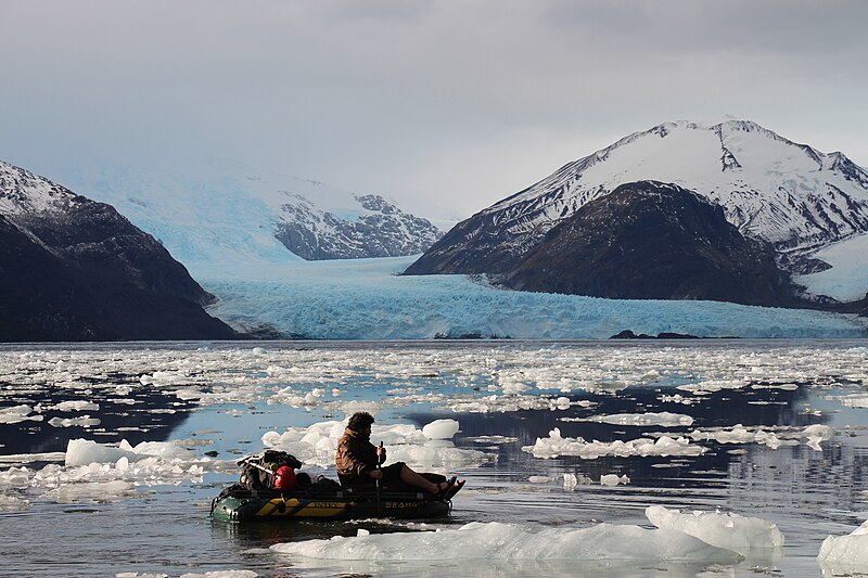
English: Boat crossing in the Amalia fjord to obtain ground cores in search of tephra of the Reclus volcano (hill of the bottom of the image) that proves a recent activity and can be related to the dynamics of the Amalia glacier (glacier in the photo). |
| Date | |
| Source | Own work |
| Author | Godiespi |
| Camera location | | View this and other nearby images on: OpenStreetMap |
|---|
The Amalia glacier and the Reclus volcano belong to Parque Nacional Bernardo O´higgins in the Región de Magallanes y la Antártica chilena in Chile.
Licensing edit
I, the copyright holder of this work, hereby publish it under the following license:
This file is licensed under the Creative Commons Attribution 4.0 International license.
- You are free:
- to share – to copy, distribute and transmit the work
- to remix – to adapt the work
- Under the following conditions:
- attribution – You must give appropriate credit, provide a link to the license, and indicate if changes were made. You may do so in any reasonable manner, but not in any way that suggests the licensor endorses you or your use.
| This image was uploaded as part of Wiki Science Competition 2017. |
File history
Click on a date/time to view the file as it appeared at that time.
| Date/Time | Thumbnail | Dimensions | User | Comment | |
|---|---|---|---|---|---|
| current | 05:26, 15 November 2017 | | 5,184 × 3,456 (2.94 MB) | Godiespi (talk | contribs) | User created page with UploadWizard |
You cannot overwrite this file.
File usage on Commons
The following 6 pages use this file:
- User:Meiræ/19
- Commons:Featured picture candidates/File:Cruce en bote fiordo Amalia.jpg
- Commons:Featured picture candidates/Log/March 2019
- Commons:Wiki Science Competition 2017/Winners/Chile
- Commons:Wiki Science Competition 2017/Winners/People in Science
- Commons:Wiki Science Competition 2017/Winners/People in Science/round 2
File usage on other wikis
The following other wikis use this file:
- Usage on uk.wikipedia.org