File:Map Crusader states 1190-pt.svg
(Redirected from File:Crusader States 1190-pt.svg)

Size of this PNG preview of this SVG file: 441 × 600 pixels. Other resolutions: 176 × 240 pixels | 353 × 480 pixels | 565 × 768 pixels | 753 × 1,024 pixels | 1,506 × 2,048 pixels | 978 × 1,330 pixels.
Original file (SVG file, nominally 978 × 1,330 pixels, file size: 91 KB)
Captions
Captions
Add a one-line explanation of what this file represents
Summary edit
| Description |
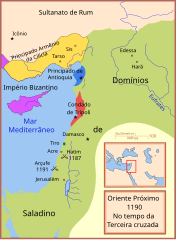
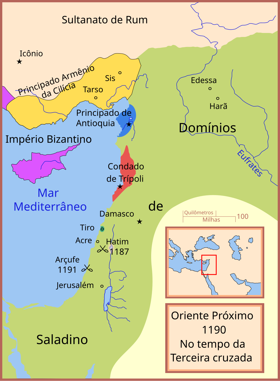
Português: Mapa do Oriente Próximo em 1190 |
| Date | |
| Source |
This file was derived from: Crusader States 1190.svg:  |
| Author | MapMaster (talk · contribs) |
| Other versions |
[]
See also edit |


Licensing edit
This file is licensed under the Creative Commons Attribution 3.0 Unported license.
- You are free:
- to share – to copy, distribute and transmit the work
- to remix – to adapt the work
- Under the following conditions:
- attribution – You must give appropriate credit, provide a link to the license, and indicate if changes were made. You may do so in any reasonable manner, but not in any way that suggests the licensor endorses you or your use.
File history
Click on a date/time to view the file as it appeared at that time.
| Date/Time | Thumbnail | Dimensions | User | Comment | |
|---|---|---|---|---|---|
| current | 00:18, 7 February 2019 | | 978 × 1,330 (91 KB) | Renato de Carvalho Ferreira (talk | contribs) | Ajustes |
| 00:58, 15 March 2018 |  | 978 × 1,330 (92 KB) | Renato de Carvalho Ferreira (talk | contribs) | Ajustes | |
| 00:05, 4 May 2013 |  | 978 × 1,330 (89 KB) | Renato de Carvalho Ferreira (talk | contribs) | Correções gerais! | |
| 22:44, 9 March 2013 |  | 978 × 1,330 (91 KB) | Renato de Carvalho Ferreira (talk | contribs) | Alterei a forma como estava disposto a legenda "domínios de Saladino" | |
| 22:32, 9 March 2013 |  | 978 × 1,330 (89 KB) | Renato de Carvalho Ferreira (talk | contribs) | User created page with UploadWizard |
You cannot overwrite this file.
File usage on Commons
The following 23 pages use this file:
- User:Geagea/Culture of Israel/2019 February 7
- User:Geagea/Geography of Israel/2019 February 7
- User:Geagea/History of Israel/2019 February 7
- User:Geagea/Israel/2018 March 15
- User:Geagea/Politics of Israel/2019 February 7
- User:Geagea/Society of Israel/2019 February 7
- File:Ciutats dels estats llatins2.png
- File:Crusader States 1190-pt.svg (file redirect)
- File:Map Crusader states 1190-ar.svg
- File:Map Crusader states 1190-arz.png
- File:Map Crusader states 1190-cs.svg
- File:Map Crusader states 1190-de.svg
- File:Map Crusader states 1190-en.svg
- File:Map Crusader states 1190-es.svg
- File:Map Crusader states 1190-fa.svg
- File:Map Crusader states 1190-fr.svg
- File:Map Crusader states 1190-fr2.svg
- File:Map Crusader states 1190-he.svg
- File:Map Crusader states 1190-it.svg
- File:Map Crusader states 1190-ka.png
- File:Map Crusader states 1190-pt.svg
- File:Map Crusader states 1190-ru.svg
- Template:Other versions/Map Crusader states 1190
File usage on other wikis
The following other wikis use this file: